Showing posts with label olympics. Show all posts

Wednesday, April 10, 2013

Little Airports Everywhere

So I had my magic carpet ride on Monday, April 1. Thankyou, AngelFlight. The morning pilot, John P., is based in Hillsboro.

My morning ride, a Cessna 182R, arriving in Port Angeles through a hole in the cloudcover, April 1, 2013 (Click for larger image.)
The Olympics from above the ceiling as we took off. April 1, 2013 (Click for larger image.)
Mount Olympus (Click for larger image.)

John came with a friend, Tod J., in the co-pilot seat; they talked the whole way about aviation electronics and the radio traffic and so on. There was low overcast almost all the way, couldn't see the ground (except for the Olympics showing off above the clouds; and the log yard and Morse Creek through a hole in the clouds before the ceiling closed in again).

The log yard, and the Morse Creek curves on US 101, Port Angeles, April 1, 2013 (Click for larger image.)

Then no ground visible until almost to Hillsboro, where we did NOT land at HIO (Portland/Hillsboro)

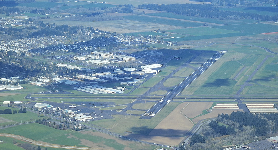
Portland/Hillsboro General Aviation Airport (HIO) where we did not land (Click for larger image.)

but at a weentsie airfield a few miles to the south called Twin Oaks Airpark (airport code 7S3). We seemed to just come down and land in the middle of farm fields, then taxi'd up a steep driveway and parked the plane in what seemed to be (and apparently was) the front yard of the owners. There are little airports everywhere. Who knew? Nice aerials on their website.

At Twin Oaks Airpark (Click for larger image.)
John and Tod at Twin Oaks (Click for larger image.)

John P.'s car was at Twin Oaks, and he completed the magic carpet effect by himself driving me into town to OHSU. He knew exactly which way to go.

Then the usual at OHSU: lab work, waiting by the entertaining 7th floor window wall (construction everywhere, no mountains visible, the tram moving up and down, checking on the progress of Zidell Marine's barge), appointment with Dr. P. As always, he was interested in the travel arrangements. I showed him a photo of John P.'s Cessna Skylane; before he moved on to the next patient, he darted off to check the aviation weather, came back to assure me that conditions were much better and the ceiling higher both at Hillsboro and in Port Angeles. After appointment, I took the streetcar

Zidell Marine's new barge as seen from near the streetcar stop at OHSU, April 1, 2013 (Click for larger image.)

and lightrail back out to Hillsboro,

MAX leaving the Fair Complex/Airport Station in Hillsboro (Click for larger image.)

walked over to the airport, and met my afternoon pilot, John V. He works for Boeing, keeps his plane in Renton (Seattle area). Much better ground visibility on the return, a smooth cheerful flight.

Chehalis River and I5 (Click for larger image.)

I was home,

The spit at the mouth of Sequim Bay, Sequim, WA. Eighth Street bridges over Valley Creek and Tumwater Creek, Port Angeles (Click for larger image.)
John V. with his Cessna 210N, Port Angeles (Click for larger image.)

back in my desk chair, not quite 8 hours after I left and not bored for a minute. Ten thousand thankyous to John, Tod, John, and AngelFlightWest.

For aircraft geeks. Inside the T210N

Wednesday, March 20, 2013

The River, The River

Another of Tom Roorda's terrific aerial photos of the mouth of the Elwha River appeared in a most informative article by Chris Dunagan from the Kitsap Sun on March 2nd. I went out Place Road and walked the dyke there on March 7th, after work at the college, for a late-afternoon low-ish tide. I wanted to see whether, if you walked as far east as you could get on the new sandspit, a different angle up the valley could give you Mt. Olympus framed by the river mouth. But it was cloudy to the south. No mountains. I walked out anyway.

March 7, 2013. Sand spit where the Elwha River meets the Strait. (Click for larger image.)

There was not a coincidence of sunny-over-the-Olympic-Mountains plus low-tide-at-an-accessible-hour until the 18th. I was working in the tribal library. The sun was out, and the wind blowing hard. People blown into the library either talked about the sunshine, or complained about the wind. I kept my eye on the clock and went, in good time. And all was changed. The river is just now flowing straight out, and turned the eastern end of the sandy flats into an island accessible only to the gulls; with side channels beyond, on the reservation side of the river.

March 18, 2013. Mount Angeles in the near reaches of the Olympic Mountains (Click for larger image.)
The river flows straight out. March 18, 2012 (Click for larger image.)
Gulls standing around where I had hoped to be. (Click for larger image.)
The east side of the river, the tribe's shore. March 18, 2013. River flowing directly past in the foreground. (Click for larger image.)
Same March 7 image as above, marked with pink brackets <> to show where the west edge of the river reached the Strait on March 18. (Click for larger image.)
Quick shaky panorama. Vancouver Island to the north on the other side of the Strait, Olympic Mountains to the south (but Mt. Olympus would be way to the right, behind the bluff and the trees)

Anne Shaffer of the Coastal Watershed Institute tells me that they had been out sampling the new and old side channels in the newly formed habitat that same sunny windy morning, and found chum salmon, coho salmon and smelt. By the time I arrived the scientists had left, and there were three schoolbuses of kids from Crescent taking their own samples from further inland along the riverbank on the west side.

So many people are watching so passionately as the river is restored. Even when there is no work ongoing on the dam removal (it's in a pause), the river is changing and changing and changing.

PS. I learned from JR that there is a cemetery belonging to the tribe to the west along the shore at the end of Place Road. How have I worked at the tribe for five years and not known about it? When I left the river, I ventured west towards the end of Place Road to see where it was. There were people in the cemetery tending to a grave, so I didn't stop to look. Wouldn't have taken pictures anyway; it's not mine to show.

Tuesday, February 26, 2013

Strait, River, Mountains. Sand.

Strait of Juan de Fuca under a very windy sky. Monday, I drove out Place Road and walked along the dyke path to where the Elwha River enters the Strait. High tide washing across the new sandy flats (1) and into the river. This all used to be a cobble wilderness, no sediment at all escaped the dams for a hundred years. But the dams are gone.

New Land in the Nearshore (Click for larger image.)

A baffling array of ripples of fibrous debris, well back from the edge of the Strait. Olympic Mountains to the south, whence the river flows.

... (Click for larger image.)

The windchill was fierce. A sunshower blew in for a moment. Sand. There was sand everywhere, burying the cobbles. Sand everywhere. I just couldn't believe it.

Strait on left, River to the right. (Click for larger image.)

Mute your sound before you watch these videos. All you can hear is the wind blowing across the camera.

Elwha River Meets the Salt, February 25, 2013
High tide, the whitecaps washing over the new sandflats, February 25, 2013.

Maybe I'll go back on Friday afternoon. The tide will be lower.

Sunday, December 23, 2012

The Watcher of Ships Watches Some Ships

Light mostly gone. Thank heavens the sunsets are going to be later now, I am done with darkness. Went out on Ediz Hook (map).

Vancouver Island on the other side of the Strait of Juan de Fuca, December 23, 2012 (Click for larger image.)

The submarine escorts (technically, offshore supply vessels) HOS Arrowhead and HOS Eagleview came in off the Strait. They always travel in pairs. It used to be Silverstar and Gemstone, but those two are no longer listed. Where have you gone, Silverstar?

HOS Arrowhead (Click for larger image.)

There were three big ships at anchor out in the harbor, the tankers Polar Discovery and Alaskan Frontier—the Polars and the Alaskans are often here, either just anchored and waiting for a day or two, or tied up at one of the piers sometimes for weeks, getting service done—and something more unusual that I couldn't get an angle on to photograph. The shiptracker sites say she is Prabhu Jivesh, an Indian ship. I can only think of one other time there was a ship from India...

Polar Discovery in Port Angeles Harbor (Click for larger image.)

There were three boat trailers parked by the small boat docks when I got out there, and a woman from Washington Department of Fish and Wildlife sitting in her pickup waiting. All three came in while I was hanging around; only one of the boats had caught anything. "A small blackmouth," said the fisherman. The WDFW lady took her clipboard out on the dock and measured the fish. Blackmouth is a winter Chinook salmon, not yet mature to begin its spawning run.

Alaskan Frontier, and a small recreational fishing boat (Click for larger image.)
The Olympic Mountains emerge briefly (Click for larger image.)

Thursday, December 13, 2012

A Sunrise

I'm in Florida doing family stuff, and thinking about home. It's hard to blog from the iPad, but here is a pinky-gold sunrise I found in the camera. December 5. Olympic Mountains to the south, Strait of Juan de Fuca to the north. Eventually I'll be back there.

Tuesday, November 06, 2012

Overview

There's a really nice article about the dam removals, with good current photos. The local paper had a gorgeous photo of sediment outflow at the mouth of the Elwha River, but I can't find the story online, so offer you instead a really nice one about salmon jumping on the Sol Duc. The dam removal process is in a fish window for the rest of the year, to avoid stirring out more sediment, a precaution which seems silly given how much will be on the move anyway if rains continue.

It's been raining. Overcast, fog, rains so light nobody bothers with raincoats or umbrellas. We are looking great for precipitation up in the Olympics and the Cascades as the water year begins. But it hasn't been cold, so it hasn't snowed yet in the mountains. This is pretty much as we have been promised: as the climate changes, more floods because storms arrive solely as rain; less water storage in snowpack to carry through the summer.

Precipitation Map from Western Regional Climate Center. Look at all that blue in the Northwest (Click for larger image.)
Snowpack map. Not nearly so pleasing. (Click for larger image.)

There was a sunbreak the morning after I got home from Florida (I did eventually get home.) And there have been several brief ones since. Everyone looks out the door or window, and wishes each other, "Enjoy the sunshine." Then it is gone.

Out the window, November 1, 2012 (Click for larger image.)

Lots going on in the realms I don't talk about here.

Saturday, October 13, 2012

Magic Carpet Ride on Monday Last

On Monday, after the monthly clinical trial checkup at OHSU, KF drove me out to Hillsboro to wait for my AngelFlight to arrive (then hustled herself back in the other direction, to PDX for her own flight home). Waited in a different place, Premier Jet Center's FBO. They knew all about the AngelFlight arriving for me, and made me welcome. (Thank you, Premier Jet Center and AngelFlight...)

October 8, 2012. Mission 170446-1 arrives at HIO to pick me up (Click for larger image.)

The weather was perfect, smooth and clear. My pilots, Aaron and CJ, kept up an entertaining conversation with each other, they were practicing flying by Instrument Flight Rules (IFR): navigating as if they couldn't see at all despite the clear endless vista out the windows of Aaron's Cessna 172.

Mount Rainier stood out clearly. As we approached the Columbia River, I could see where Great Vow Monastery had to be, where we were on Sunday; took a picture though the temporary camera is not so interested in getting images through airplane windows.

Approaching the Columbia, and looking out towards the Pacific Ocean (Click for larger image.)
Roughly the same view, on Google Earth. Pin marks Great Vow Zen Monastery. (Click for larger image.)

The Olympics put on a spectacular show.

Looking into the Realm of the Gods, the east rampart of the Olympic Mountains, Hood Canal in foreground (Click for larger image.)

Coming around the corner to head west along the Strait, saw an interesting landform detail which turns out to be Mats Mats Bay near Port Ludlow (no pic); clearly picked out Graysmarsh along the north Sequim shore, flew in over the log yard and T-pier where POS Leader was still docked (were they EVER going to sail?),

Greysmarsh (Click for larger image.)
POS Leader and the log yard, Port Angeles Harbor (Click for larger image.)

and home. Thank you so much to Aaron and CJ.

October 8, 2012. Mission 170446-1 at Port Angeles (Click for larger image.)

PS for PG & DG: POS Leader finally sailed Tuesday evening; is now en route to Lianyungang, north of Shanghai. (map)

PS for Aaron and CJ. The previous Angel Flights I have flown on were a Cessna 172SP, a Grumman American AA-5, a Cessna T210, and I don't seem to have a record of the 4th one. (photo) Next month I'll ask Dr. Pommier what he flies, and let you know.

Sunday, September 02, 2012

Mountain Ocean Etc.

We made two forays into Olympic National Park. We went up to Hurricane Ridge on Sunday morning. The air was a bit murky, the view was not glorious, the wildflowers all but over, and our total wildlife tally for the week appeared in the person of one deer in the Hurricane Hill trailhead parking lot. None of this floated EBD's boat, though she was politely appreciative.

August 26, 2012. Late season flowers on the Hurricane Hill Trail. (Click for larger image.)
The Bailey Range and Mount Olympus, morning, August 26, 2012 (Click for larger image.)

On Monday, we went out to the outer coast, to Rialto Beach. EBD mentioned that people do not seem to swim in our ocean. "Honey," I said, "people do not swim in the ocean anywhere north of Santa Barbara. You have the Atlantic Coastal Plain's flat sandy beaches, and the Gulf Stream to warm them, all the way north to Cape Cod. We have cold currents coming down from the Gulf of Alaska, and mostly rocky places." This did not clarify matters for her. Later she mentioned politely that it was "a very unusual beach."

Kite Weather on Rialto Beach, August 27, 2012 (Click for larger image.)
The Tide Was Going Out (Click for larger image.)

Sunday, August 12, 2012

In Which Many Places Happen

On Wednesday, went with EW to Neah Bay. She spent two happy hours in the Makah Museum, then we went on to Hobuck Beach. There were gulls, and quietness, one intact sand dollar, one passing eagle, and one dead bird (a gull). EW lives in the desert. All our greenness and damp air and oceans and so on, including grey skies and bits of rain, are very pleasurable for her.

Hobuck Beach, August 8, 2012. Sand dollar, Dendraster eccentricus (Click for larger image.)

On Thursday, a very full perfect day. Over we went on the ferry to Victoria. Ferry was late on account of thick fog, was foghorning itself along for 3/4s of the trip until popping out into the sunshine, then got stuck behind a huge double barge full of dirt (huh?) on its way into the Inner Harbor, then when finally the ferry could move it went too fast and failed to stick its landing, had to try a second time to line up the ramps correctly before we could debark.

Houseboats in the Inner Harbor, Olympic Mountains on the skyline across the Strait, Victoria, BC, August 9, 2012 (Click for larger image.)

For these three reasons we lost nearly an hour of our planned time in the Royal BC Museum, which turned out to be ok with me because I had become disoriented and claustrophopic in there and had to go outside, even though the First Nations artifacts were amazing, mural-sized vintage photos are a whole different experience from seeing the same ones in books, and the dinosaur exhibit was also terrific.

T Rex, Royal BC Museum, Victoria (Click for larger image.)

Then we trotted off to our reservation for high tea at the Empress Hotel, EW's lunatic desire. Finger sandwiches, scones, little tartlets and other fancy desserts, all on a three-story stand and much tea and faux Brit elegance at vast expense (EW's expense). You put the milk in first if you are having proper British tea. And of course you let the waiter pour to refill your cup. EW got up, refilled her own cup and put the milk in after. The waiter pretended to reprimand her. 'M.I.F. is the rule. Milk in first.'

WC fetched us from the curb in front of the hotel after tea, and off we drove west along the shore to an easy-access beach. This was carefully planned by me: Wednesday we drove west to Neah Bay and back on the Olympic Peninsula shore of the Strait of Juan de Fuca, and Thursday I wanted us on the Vancouver Island side, looking back across to where we had been. The weather cooperated. West we went to French Beach Provincial Park, admiring the other side across the blue water all the way along. EW and I took off our shoes and got our feet wet, then she flopped out for a nap on the cobble shore while WC and I sat on a log and discussed my health. (Sigh.)

French Beach Provincial Park, August 10, 2012 (Click for larger image.)

Leisurely indirect drive back into Victoria proper, and an impromptu early supper in WC & PW's sun porch, pizza and leftovers of our Empress high tea goodies. It was fine. They dropped us off at the ferry terminal early and went home to presumably do something more sensible about their dinner, and EW and I had a happy time loving the Victoria harbor and all its activity. Sea planes, water taxis, the Clipper setting forth, etc etc while we waited for the ferry, which was again running a little bit late. We sailed for home. A brass band on a small boat paralleled the ferry as we departed the harbor, giving us a mariachi serenade. We waved and cheered for them. Woo hoo. I mean, really, whatever gods orchestrated this day outdid themselves. A waterborne mariachi band sendoff?

It would be sort of terrific to live on a houseboat and let the water taxi deliver your groceries, no? (Click for larger image.)
Mariachi Send-Off in the Inner Harbor (Click for larger image.)

So Friday we went up to Hurricane Ridge. Conditions were against us. The air was thick with Asian smoke again, as it was a few weeks ago; you could barely even see Mount Olympus; also the road to the Hurricane Hill trailhead was closed for paving work. By necessity we stuck to the trails near the Visitor Center, and managed to have a tiny bit of Lupine Heaven even in the flat smoky light.

Bailey Range & Mt. Olympus behind, in smoky air, August 10, 2012 (Click for larger image.)
Lupine Heaven on Hurricane Ridge, August 10, 2012 (Click for larger image.)

Saturday we went to Rialto Beach. See next post.