Showing posts with label Lillian_Ridge. Show all posts

Sunday, July 10, 2011

Signs, Signals, and Webcams

I went and asked at the Olympic National Park visitor center here in town about when the Obstruction Point Road might open. A volunteer docent said her husband had hiked to the end of the road this week, and had needed an ice axe to keep his footing getting across the iced-over drifts in the road in some places. She guessed mid-August. A ranger guy guessed late August. No houseguests are getting onto the Lillian Ridge Trail in the near future...

The road conditions recording says there are 44" of snow at the snow stake, wherever that is; somewhere on the north side of the hill above the Hurricane Ridge visitor center, perhaps the nubbin in the background on the northcam,

Hurricane Ridge Web Cam, Parking Lot View (Click for larger image.)

the view of the parking lot on Hurricane Ridge. There are almost always deer in the cam view that looks southwest towards Mt. Olympus. Are people feeding them, or is there just more fresh grass on this slope than elsewhere in the vicinity? There are those 44" of snow nearby to factor in...

Hurricane Ridge Web Cam, Looking Towards the Bailey Range and Mount Olympus (Click for larger image.)

Enough with the addictive-behavior reading orgy. I really am heading for the outer coast this morning.

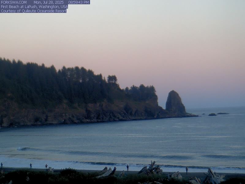
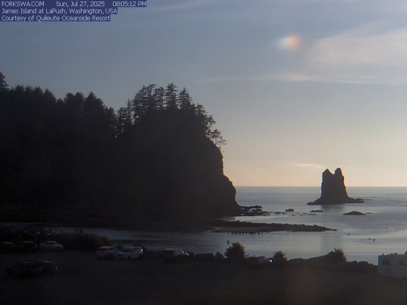
La Push Web Cams (1)(2), Right Now (Click for larger image.)

Thursday, April 28, 2011

Anticipating Marmots

Still snowing up there. I wonder if there are years when the road out to Lillian Ridge never is opened at all? Last year it was open only mid-July to mid-October. Marmots. I need to be able to anticipate marmots.

The Waterhole SnoTel, halfway out to Obstruction Point on Hurricane Ridge (Click for larger image.)

Friday, October 15, 2010

The Weekend Lingers...

AW put her marmot movie up on youtube. Our marmot on Sunday right by the road. Don't read another word until you have watched it. Really. Go now.

On Wednesday after work I went back up the mountain to try to figure out the flaming bushes we took pictures of on Sunday. Bounced on out the Obstruction Point Road to just before the halfway point, to the very patch we took the pictures of. It had to be one of the huckleberries

Original picture, huckleberry patch, October 10, 2010 (Click for larger image.)

most likely blue leaf (Vaccinium deliciosum) because that is the one which grows in big patches that turn red in the fall, except every single book says that Vaccinium deliciosum is at most 12" tall and a lot of the ones along the road were way taller than that. Tim McNulty says it is so, and a ranger identified it for PG & me a couple of Octobers ago— BUT from a distance. I've never looked up close at the red patches painting the mountainsides and thought, 'This is what grows in a red patch, this is the stuff.'

In the books it is shown with very fine teeth around the leaves. You think they are smooth until you look closely. Check. Turned bright red. Check. A few very partial dried up huckleberry-ish berries left on them. Check. Ma-a-a-ybe it's a different huckleberry, but it's gotta be almost right. Until corrected, Vaccinium deliciosum.

Huckleberry patch close-up, October 14, 2010 (Click for larger image.)

As to Monday, we have done much research about pelicans, put in interlibrary loan requests for articles about their range and behavior, etc etc., and will report as information arrives. This morning we discovered that Sam Beebe's Ecotrust aerial photos of the Coast are available for use. Oh my. Thank you Mr. Beebe, thank you Creative Commons.

La Push & First Beach. Rialto is just off to the left. Mount Olympus on the horizon (!) (Click for larger image.)
Photo: Samuel M Beebe/Ecotrust, Creative Commons Attribution 3.0

Monday, October 11, 2010

Foray into Shangri-La

A. came over on the noon ferry. The weather had turned glorious on the crossing, and we darted straight up the mountain.

Destination, Obstruction Point. From Victoria, the Olympics sometimes loom as massive and delectable as Himalayas on the horizon; and I'd promised her this magical foray towards Shangri-La.

... (Click for larger image.)

"Here's where the marmots were," I said as we rolled along, and whoah, there they were.

The marmots' context (Click for larger image.)
Two marmots. Energetic and not too fat. Young ones? (Click for larger image.)

The road's been open since the middle of July, and will close as soon as it snows. We walked a little distance along the Lillian Ridge trail, windy, cold, beautiful. It got darker, clouds were moving in, maybe. Time to go? Goodbye for eight or ten months, paradise.

Autumn on Lillian Ridge (Click for larger image.)
This one is A's photo... (Click for larger image.)

Except I may have to go back up after work one day this week to examine the amazing flaming bushes by the road in the woods. What on earth are they, and why did I not look more closely after I decided, no, I may not pick a leaf....

Luckily there are some quite close to the beginning of the road... (Click for larger image.)

Wednesday, September 01, 2010

Visit Road Day #1 Continued

Sunday. The Obstruction Point trip included other wildlife manifestations: chipmunks, deer along the highway and (especially) carefully examining all the cars at the Obstruction Point Trailhead, raptors out over empty space cruising the long drop to Lillian River, a report of mother bear and cub down by the little lake below the big stone steps (those we did not see; I say we get to count them, S. says not)(see PS below); a single raptor where the ridge was still narrow, who cruised up out of nowhere, skimmed across the road and down the other side, showing a white rump patch and must have been a northern harrier (the former marshhawk) though the habitat was all wrong. Some wildflowers left.

Still it was 'the marmot trip'; all the rest, including the vast sweeps of landscape, were just rolled into what in memory was a successful marmot quest. After the marmots, we went on to do four more things. A lunch in town: seafood by the harbor. Then on to pick blackberries from the roadside bushes behind the store at Laird's Corner. Since we were arriving on purpose with containers and a determined crew of two, I went in the store and asked permission. Which was cheerfully granted.

Then on westward, along the lake to the trailhead to walk on the trail to Marymere Falls. There was Barnes Creek, and some quite nice forest, and quite a lot of people speaking a good many different languages. We did not go up the stairs to the falls viewpoint, making do with creek and forest. There was some sun.

Barnes Creek Trail, 08/29/2010 (Click for larger image.)

Still the good weather was hanging on. On the way home we detoured down to Ediz Hook to look for ships and birds. There were a couple of big tankers in the harbor— a Polar at the terminal being worked on, an Alaskan at anchor — but no ship traffic on the Strait except a rapidly receding inbound ship. The pilot boat was just returning from having put a pilot aboard her. Some kids had found something interesting off the small boat dock. They got some sticks and went back out, the better to investigate. A couple of maybe cormorants, and gulls. No other birds.

Port Angeles Harbor (Click for larger image.)

*PS This makes sense as the little lake down there is surrounded by blue-leaf huckleberry, which goes conspicuously red in the fall, creating mysterious colorpatches all over the landscape— P. and I saw it that way around the lakelet a couple of autumns ago— and Tim McNulty says, "Black bears Ursus Americanus), are seen frequently in the high meadows in late summer, most often snout down in a patch of huckleberries." (p.77).

Tim M. also has pages and pages of loving prose about Olympic marmots. "One of the many traits I've always admired in marmots is their fondness for wide front porches..." S.'s iPhone maps our marmot photos as being here, which looks right. Ridge behind dropping into Lillian River. The front porch view out over the unnamed upper reaches of Maiden Creek...


Monday, August 30, 2010

The Marmot's View

About a mile before Obstruction Point, there was a marmot by the road. He ran off, insofar as running is an option for a fatty like this one, and stopped not very far away, on a burrow entry that looks out northeastward over empty space. He was whistling, or perhaps another marmot we couldn't spot was whistling.

A Marmot At Home, August 29, 2010 (Click for larger image.)

This was the day before the weather was going to change, and we crammed as much as we could into it, that Houseguest Sprint we Olympic Peninsula people do when visitors come from places like Cincinnati :-) So up we were and toodling along the Obstruction Point Road, looking for scenery and marmots at quite the early hour. Succeeded.

Where the Marmot Was, August 29, 2010 (Click for larger image.)

This is probably what the marmot was looking at when we startled him away from the road:

The View in the Other Direction, August 29, 2010 (Click for larger image.)

Eventually we went on to the end of the road and had a walk along Lillian Ridge. There were in fact no marmots in the hollow by the parking lot where they usually frolic. It was mostly brown up there, but the green in this image isn't enhanced, just selected for :-) More about the rest of the day in next post.

Lillian Ridge Trail view, August 29, 2010 (Click for larger image.)

Wednesday, August 11, 2010

Marmot Quest #Fail

We went to Obstruction Point, as L. wanted to see marmots. Naturally they were all hiding. We weren't up for hiking. The mountains were in fine fettle, however, and there were flowers, and flitty little chipmunks.

Here There (Should) Be Marmots (Click for larger image.)

Friday, October 02, 2009

Three Months After the Road Opened

The Obstruction Point Road is about ready to close again. Soon the gate will close at the point where the dirt road leaves the Hurricane Ridge Road, up by the visitor center; already they warn you:

There was a bit of snow on the road going out in the morning, much less by afternoon returning. The clouds never quite cleared off Mt. Olympus, a twilighty sunshine came and went. Frost outlined the grasses. The marmots are gone down into their burrows.

Lillian Ridge Trail at Obstruction Point, October 2, 2009 (Click for larger image.)


WC saw a pod of orcas from the ferry on his way across yesterday morning. In the afternoon we tried for salmon leaping up the Cascade on the Sol Duc River. But though there were more salmon in the pool below the Cascade than there were a week ago, they are still not jumping. What happens if the river never fluffs up? Will they eventually move anyway? Or do this year's returning salmon never spawn?

Tomorrow we try (again) to see the turkey vulture migration at Salt Creek.

Friday, July 17, 2009

The Vastest of Landscapes

It's hard to believe you just get to be there. You should have to backpack for miles to get to such a place, carrying weight and striving mightily to get into the remotest back country; but no, you just drive out a dirt road eight miles from the pavement, and arrive in heaven. Heaven with flowers. Along the road on the inboard side was what my friend P. calls Botticelli meadows: slopes and sweeps and swathes of mixed flowers, patches of avalanche lilies and magenta paintbrush and sitka valerian and lupines and veronica and polemonium and dephinium, and lupines and lupines and lupines. Off the other shoulder of the road, views on an astonishing scale. Here is the best place to get a good look at Mount Olympus, no longer hidden by the Bailey Range but Out There. Extremely out there.

Along the Obstruction Point Road
Along the Obstruction Point Road (Click for larger image)

The road opened for the season July 4th weekend; it will be closed by the first snows, long about October. (map; pink for unpaved road, purple for trail)

We hiked about an hour along the trail, in dazzling sunshine, frequently flopping down in the middle of the trail, or stepping cautiously off-trail on patches of talus, with books and notebook for identifying wildflowers. We heard a marmot calling, looked out and first saw only a deer walking across a rise in the usual marmot hollow. Then we saw him, far away, then he vanished down a burrow.

Lillian Ridge Trail from Obstruction Point

It's pretty dry up there on the ridgetop, conditions always demanding for the plants and this past winter only 70% normal snowpack and a long dry spring. For lavish, the roadside slopes were much better, but here anyway many determined alpine flowers were doing their job of blooming and setting seed in the vastest of landscapes.

Lillian Ridge Trail (Click for larger image.)

When we got back to the parking lot, we had our own private marmot. He was popping in and out of his burrow, and looking around, and watching us. Right. Next. To. The. Car.

The Marmot (Click for larger image.)

Friday, September 19, 2008

Winter Coming Soon: Lillian Ridge

Out to Obstruction Point with P. We were above the clouds that have blanketed town for the past two days, but the air was murky up there. (Maybe smoke in the air. There's fires in Oregon.)

We hiked a little ways in, had a picnic, looked and looked and looked for marmots. It was lavishly beautiful; but dry; and everything seemed over, finished, shutting down, winter-coming, though it was warm warm warm. We saw a horned lark in the grass. Many scarlet patches of Vaccinium deliciosum, all over the landscape. Accenting tiny lakes, and scattered down the slopes.

P. heads down to look for a patch of scarlet berry leaves. (Click for larger image).
Patches of Cascade blueberry, leaves turned scarlet. (Click for larger image).

A mile or so down the road on our way out, a marmot was sitting on top of his burrow, very close to the road. Oh he was so cute, with his little white nose and his body so fat, so ready to hibernate. Didn't try to get a picture, getting out of the car would have scared him off. Sleep well, marmot. See you next year.

Looking back: because we might not see it again until next July. (Click for larger image).

PS Hunting around for some history that explains why there is this astonishing road straight to paradise, I found the Kaleberg's beautiful page of photos taken up there this week. Lots of red, and before the foggy (smoky?) air moved in. Found the history on Nature Education Enterprises blog.

Thursday, September 04, 2008

The Visit: Heard a Marmot, Saw a Marmot

Late on Thursday afternoon we drove up onto Hurricane Ridge and then out the dirt road to Obstruction Point and headed up the trail along Lillian Ridge. Almost right away we heard a marmot whistling, right where all the trail books say to watch for marmots. We looked and looked, and finally spotted him, sunning on a rock on the far side of the hollow. He/she was just hanging out on a rock, whistling.

Where the marmot was, elevation 6100' on Lillian Ridge

We hiked along the trail to the next little rise, and then another, one eye on the time because we had a long way to go to get back to town before dark. There were not so many flowers. The sun got lower in the sky, the light more lavish. When we came back the marmot was quiet, but still on his rock. With the sun behind him he cast a tiny far-away shadow on the bit of meadow below. We enjoyed the idea that he spends most of his time looking at the world from his rock, except when he goes in his burrow, which we imagined must be right there under the rock

The View from a bit further on and higher up

PS The revision of the Park website has caused their photo of an Olympic Marmot to vanish. Here it is, as retrieved from the Wayback Machine.

Thursday, August 23, 2007

Lillian Ridge Trail in Changeable Weather

About 40 minutes in from the trailhead on Obstruction Point Road. (Click for larger image.)