Showing posts with label journeys. Show all posts

Saturday, April 12, 2014

Ocean in View Post #980

This post is actually being written by RF, who is in Port Angeles visiting Miriam for several days. Life's vicissitudes are unfortunately leading not only to the waning of the blog but to the necessity for Miriam to leave this spectacularly lush and beautiful part of the world to return to one associated with beauty of a very different and far more austere kind for the remainder of her days.

I for one have enjoyed reading the posts from afar, and feel that the blog deserves some kind of ceremony in honor of its cessation. Finding out that this post is the 980th to be published makes me want to try to figure out some way to squeeze out another 20, so that it can celebrate post #1000, but I don't think that it's going to happen. Speaking on behalf of Miriam, I would like to thank everyone who has read or commented over the years. I also want to encourage anyone reading this to remember to keep your eyes open to the wonders of both the natural and human-constructed worlds, and to help others share in the sensations to be had.

If there is no post #981, take care. If there is a post #981, we'll see you then.

Sunday, July 21, 2013

A Frog in a Pond in a Desert

I was in New Mexico for a week, visiting friends. Spent time in familiar homes and on people's patios and in people's yards. Drove familiar streets, and ate in familiar restaurants. Was feted with a wonderful party. Sat watching prairie dogs pop out of holes in Amelia White Park up near Museum Hill, and watched pavilions go up for the International Folk Art Market, and fell in love with Santa Fe's South Capitol neighborhood, and almost understood the real charm of what has been perverted into rich people's Style.

But overall we were having trouble finding anyplace we could GO because there were fires everywhere and the national forests were all under restriction, and hikers and sitters-by-rivers alike were locked out of their refuges. So it was particularly absurd and pleasing for RF and me to find ourselves listening to a bullfrog on the far side of a natural pond in the Leonora Curtin Wetland Preserve, south of town on the I5 frontage road by La Cienega, surrounded by the droughty droughty landscape, the air filled with smoke. There was water, and plants, and waterbirds.

July 6, 2013. This is not the bullfrog. But we heard him. (Click for larger image.)

From New Mexico went on to Florida, for family stuff. Then home again. Time flies when you're not feeling communicative.

Sunday, June 30, 2013

Walking To Victoria

According to the photos in the camera, the following things happened in the three weeks since I last posted.

On June 14, I attended a field day at the west side of the mouth of the Elwha, where various little fishes were seined up, identified, measured, scanned for tiny embedded wire tags that say which hatchery they were born in, and let go again. There were lots of scientists, interns, and locals participating. The Peninsula Daily News had a very nice story about the day.

Elwha estuary, June 14, 2013. Two of the three ponds they seined. (Click for larger image.)

June 16, a deer hung around the neighborhood, performing such deer-ish tricks as eating all my landlady's beautiful new deep orange pansies, and parading down the middle of 8th Street grazing the yellow paint of the center line.

June 22, I went to Tukwila to a support group meeting for people with my kind of cancer.

June 25, LR texted the tribe's Education Director from out by the mouth of the Elwha on the tribe's side; there was a super-low tide, and she said we had to come out immediately, it's amazing. So we tumbled into the car and went. We were playing hooky from work in the education building, but when it was time to head back lest we miss Elder's Lunch (lasagna!!), I announced "I'm walking to Victoria!" and headed north toward the soft silty edge of the mudflats. LR and TH followed me out to as far as we could get. It was amazing.

LR rushing to greet us. The new silty lands at the mouth of the Elwha, June 26, 2013 (Click for larger image.)

June 25, picked WC up at the ferry, and June 26 we drove down to Portland for the bimonthly CT scans. I'm still stable, still in the clinical trial, still a science project. We did it as a day trip, left at 4:50 AM and made it home in time to put him on the 9:30 PM ferry.

Yet another ferry view, June 26, and the pylons for the new MAX light rail line, Portland, June 27, 2013. (Click for larger image.)

June 28, the canoes were out of the storage shed and arrayed on the lawn between the Education Building and the Tribal Center. Canoe journey is less than a month away, there must be practicing and preparation and cold-water training and all for the pullers.

Three of Elwha's four canoes. June 28, 2013 (Click for larger image.)

I never got to the ocean at all.

On the whole, every picture in the camera is as flat as my spirits these days. This is a beachbunny blog, supposed to be a mostly effortless, nearly chirpy picture of places gone and things seen. I don't much want to change the ground rules I set for myself and start posting lugubrious paragraphs about my state of mind. I also don't want it to be drudgery to post. Yet I don't want to lose three weeks at a time out of the record I have kept of my life since I decided to move up here, even if all I really want to do is read, not write. It's a puzzle.

Meanwhile, here is a picture showing the Elwha River's east and west shores and the shifting channels, taken by Mike McHenry of the Lower Elwha Klallam Tribe on June 11, 2013.

Elwha River overflight, June 11, 2013. Thanks to Mike McHenry and the Lower Elwha Klallam Tribe for this photo. (Click for larger image.)

Sorry. The image template changed, and I don't have time to deal with it. Am packing to leave for Santa Fe and then Florida at impossible AM. It will just have to be what it is until I get home.

This post is for KL and RC, who were worrying about my silence.

Monday, June 10, 2013

Planes and Boats and Trains

May 30th, one-day trip to Portland for the monthly medical adventure.

This was planned to be an Angelflight trip, but the weather was unstable all week and no pilot signed up for the southbound mission. At the last minute arranged to fly to Seattle on Kenmore Air, then Alaska Air to Portland. The actual tally of modes of transportation was six: car to the airport in Port Angeles, Kenmore's Cessna to Boeing Field, van shuttle to SeaTac, commuter plane to Portland, light rail from PDX to downtown, streetcar to OHSU on the South Waterfront.

Peninsula College (where I work) from the Kenmore Air flight, May 30, 2013 (Click for larger image.)

The familiar activities at the clinic building, Oregon Health and Science University's Center for Health and Healing: lab work, something to eat and some coffee, waiting to see Dr. P. up on the 7th floor, talking to doctor, interns, research assistants, the research nurse. (It's a clinical trial, you will remember. I am a science project.) Posting to twitter. Studying the view through the window wall.

Zidell Yards has started laying a new barge down there by the foot of the tramway. They made visible progress just in the couple of hours I was there. The previous barge— last seen on April 29 down on the ramp, apparently ready for launch— actually didn't set sail until May 22. South Waterfront blog has pictures. Its final paint job proclaims ST-23 a Shaver Transportation barge, and it's now on their fleet list. ST-23 will be going up and down through the locks on the Columbia River, carrying grain. Good luck to you, barge.

The Aerial Tram sails past the window wall on the 7th floor. May 30, 2013. (Click for larger image.)
Zidell Marine's new barge makes progress already (Click for larger image.)

The northbound transportation arrangements had rearranged themselves in the course of the day, with much emailing and mobile-phoning. My northbound Angelflight pilot, Jeremy, thought conditions weren't good for him to pick me up at the general aviation airport in Hillsboro (ice aloft), so he arranged a ticket for me on Alaska Air to Seattle, where he would pick me up and fly me on to Port Angeles. So the ground transportation Earth Angel, Tom, changed his plan and instead of fetching me to Hillsboro, he and his wife drove me out to PDX. I got on standby for an earlier flight than the one booked, and pretty soon was in Seattle. Jeremy met me at the curb and we headed through rush hour traffic for Renton Municipal Airport (map), where his flying club keeps its planes.

Getting ready in Renton (Click for larger image.)

Starting from someplace entirely different, the line of flight was all new territory until after we crossed Hood Canal.

Part of our line of flight. (Click for larger image.)

Then the camera lost the GPS signal, alas, so pins on the photo app stop there, and I can't tell just where we were for this random view of green Sequim hinterlands...

Sequim below, May 30, 2013 (Click for larger image.)
The log yard is filling up again; Port Angeles harbor. (Click for larger image.)

Jeremy made a featherlight landing in Port Angeles, and pulled in to Rite Brothers FBO. I walked down the way to the airport terminal, where I had left my car at 5AM, so many transitions ago it was impossible to believe it was still the same day.

Thank you to Jeremy, Tom, and Angelflight, and all the kindly people at OHSU, too.

Back in Port Angeles (Click for larger image.)

Sea Voyage to Another Country (Again)

May 24th, went over to Victoria to hang out with PW and WC. It was a beautiful morning for the crossing.

May 24, 2013. Port Angeles from the stern deck of the ferry. Looking good. (Click for larger image.)
Still sunny when we got to the other side. Victoria Harbor, May 24, 2013 (Click for larger image.)

Usually we drive west along the West Coast Road, it's a reflex: 'I dunno, why don't we head out to French Beach, maybe we could have a fancy dessert at the Point No Point Inn and look across the Strait to Clallam Bay, ooh, shall we go to Jordan River.' This time instead we went not west but north, where Victoria proper backs up into the Saanich Peninsula and becomes Greater Victoria. We went to Quick's Bottom Park and took a walk. It's a wetland, it was quite preposterously green. Managed to find the decrepit old bird blind, though it was midday and not many birds to see (and no pix). We ventured onto back roads.

Quick's Bottom, Saanich, BC. May 24, 2013 (Click for larger image.)

The next day we set forth in search of Gowlland Tod Provincial Park. It was rumored to be an easy walk to Tod Inlet. We trundled down a ways along the slope below where Butchart Gardens is, then came to a trail sign that made clear there was much further to go, and besides it was thinking about raining, so we turned back.

Random woodsiness on the trail to Tod Inlet, May 25, 2013 (Click for larger image.)

We had lunch in Brentwood Bay, while it absolutely poured down rain into the marina and on all the decks of the restaurant. Then explored local roads. Went out to Willis Point, wherever that is (by then I was turned around 180 degrees, thought we were looking east when we were looking west).

The end of the road at Willis Point, where the houses run out and by golly there's a boundary sign for Gowlland Tod Provincial Park. Where for heaven's sake were we? (Click for larger image.)

A rest, a quick stop to say hello to one of PW's daughters at her downtown job, and I was back on the ferry for the journey home. As usual, took several dozen photos of water taxis while the ferry loaded; also seaplanes, tall ships, cruise liners. It started raining again halfway across the Strait.

The Coho coming in (Click for larger image.)
(Click for larger image.)
The flock of cruise ships that will leave before midnight, arrive in Seattle the next morning, and set sail again at 4PM. (Click for larger image.)

The bottom pins are Victoria harbor. The one to the east, WC & PW's yard. In the middle of the peninsula, Quick's Bottom by the highway 17 sign, Tod Inlet righthand upper pin, Willis Point to the left.

(Click for larger image.)

Saturday, May 04, 2013

Journey North Says, and Other Updates

Shoutout to @jfleck , who writes about water and climate at the Albuquerque Journal, for this new-to-me visualizer, the WPC Quantitative Precipitation Forecasts. I really shouldn't complain, but it's relentlessly sunny here right now. My inclination is to cower indoors.

Journey North's Gray Whale section says it's "rush hour for moms and babies". Since I'm not going to get out to La Push at a low tide before I have to head for Florida again, that will have to do for whale news. For not-news, look again at the post about seeing a whale on April 21.

Work on the Elwha River's dam removal project is stopped for at least another month while the National Park and the contractors and the city and the tribe and other water users sort out the sad fact that the new water treatment plant and all its intake works were underdesigned and have been overwhelmed by silt and debris coming down the river from behind the former dams. It's more fun to think about the ever-changing re-making of the river itself and the nearshore. Once again Tom Roorda has been way up in the middle of the air looking at it, and sharing what he sees. New land continues to grow on the rez side of the river.

The Elwha River flows into the Strait, May 1. Thank you to Tom Roorda for permission to show this image. (Click for larger image.)

Did I mention the days are long?

Saturday
4 May 2013 Pacific Daylight Time
SUN
Begin civil twilight 5:15 a.m.
Sunrise 5:50 a.m.
Sunset 8:32 p.m.
End civil twilight 9:08 p.m.

It's starting to melt up on Hurricane Ridge, but there's still a lot of snow up there and on into the high country. Will the Obstruction Point Road open for July 4th weekend? Seems unlikely; last year it wasn't open until the middle of August. I stare at the lines on the graph and try to guess.

Snow-Water Equivalent at the Waterhole Snotel, May 4, 2013 (Click for larger image.)

Went to Portland on April 29. The daylight is long, we did it as a day trip. Drive drive drive, lab work, consult clinical trial doctor, drive drive drive some more, back home again. I'm still stable, still in the trial. There was big news for a shipwatcher: Zidell Marine's current barge under construction, which I've been watching month by month from the windows of OHSU, seems to be finished. All fresh paint, and waiting down on the ramp leading into the Willamette River. It's now five days later, but either it hasn't launched yet, or the Portland news sites aren't reporting on her launch. She's not listed yet on the amazingly long list of barges Zidell Yards has built in its various incarnations, presently Zidell Marine.

Zidell Marine's barge ST 23 from the windows of the lab on the 3rd floor of OHSU, April 29, 2013 (Click for larger image.)
...from the windows of the oncology waiting area, 7th floor of OHSU, April 29, 2013 (Click for larger image.)

Saturday, April 20, 2013

DEN

Just returned from a trip to Florida for family stuff. Changed planes in Saint Louis eastbound, in Denver on the return. Long layover at DEN, and I had a good wander. Not much in the way of amenities at the far end of Concourse C. But there on the windows, Machado.

Airport art, Denver (Click for larger image.)

Flying out of Denver, had a good wave at @susanbdot and @pixelmountain, then the clouds closed in below and we didn't see the ground again until Seattle. I surely looove Southwest's flight tracker...

Horsetooth Reservoir and Fort Collins, CO (Click for larger image.)

Wednesday, April 10, 2013

Little Airports Everywhere

So I had my magic carpet ride on Monday, April 1. Thankyou, AngelFlight. The morning pilot, John P., is based in Hillsboro.

My morning ride, a Cessna 182R, arriving in Port Angeles through a hole in the cloudcover, April 1, 2013 (Click for larger image.)
The Olympics from above the ceiling as we took off. April 1, 2013 (Click for larger image.)
Mount Olympus (Click for larger image.)

John came with a friend, Tod J., in the co-pilot seat; they talked the whole way about aviation electronics and the radio traffic and so on. There was low overcast almost all the way, couldn't see the ground (except for the Olympics showing off above the clouds; and the log yard and Morse Creek through a hole in the clouds before the ceiling closed in again).

The log yard, and the Morse Creek curves on US 101, Port Angeles, April 1, 2013 (Click for larger image.)

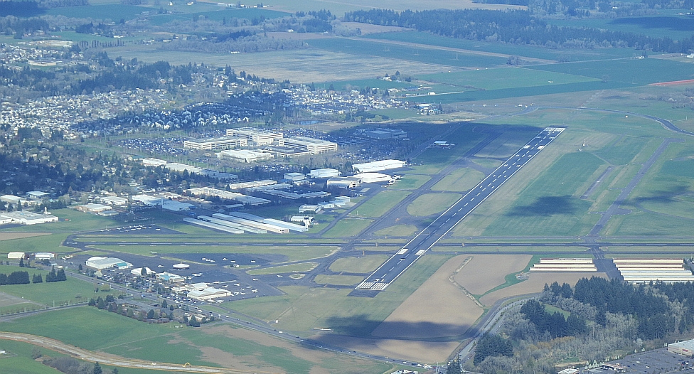
Then no ground visible until almost to Hillsboro, where we did NOT land at HIO (Portland/Hillsboro)

Portland/Hillsboro General Aviation Airport (HIO) where we did not land (Click for larger image.)

but at a weentsie airfield a few miles to the south called Twin Oaks Airpark (airport code 7S3). We seemed to just come down and land in the middle of farm fields, then taxi'd up a steep driveway and parked the plane in what seemed to be (and apparently was) the front yard of the owners. There are little airports everywhere. Who knew? Nice aerials on their website.

At Twin Oaks Airpark (Click for larger image.)
John and Tod at Twin Oaks (Click for larger image.)

John P.'s car was at Twin Oaks, and he completed the magic carpet effect by himself driving me into town to OHSU. He knew exactly which way to go.

Then the usual at OHSU: lab work, waiting by the entertaining 7th floor window wall (construction everywhere, no mountains visible, the tram moving up and down, checking on the progress of Zidell Marine's barge), appointment with Dr. P. As always, he was interested in the travel arrangements. I showed him a photo of John P.'s Cessna Skylane; before he moved on to the next patient, he darted off to check the aviation weather, came back to assure me that conditions were much better and the ceiling higher both at Hillsboro and in Port Angeles. After appointment, I took the streetcar

Zidell Marine's new barge as seen from near the streetcar stop at OHSU, April 1, 2013 (Click for larger image.)

and lightrail back out to Hillsboro,

MAX leaving the Fair Complex/Airport Station in Hillsboro (Click for larger image.)

walked over to the airport, and met my afternoon pilot, John V. He works for Boeing, keeps his plane in Renton (Seattle area). Much better ground visibility on the return, a smooth cheerful flight.

Chehalis River and I5 (Click for larger image.)

I was home,

The spit at the mouth of Sequim Bay, Sequim, WA. Eighth Street bridges over Valley Creek and Tumwater Creek, Port Angeles (Click for larger image.)
John V. with his Cessna 210N, Port Angeles (Click for larger image.)

back in my desk chair, not quite 8 hours after I left and not bored for a minute. Ten thousand thankyous to John, Tod, John, and AngelFlightWest.

For aircraft geeks. Inside the T210N