Showing posts with label second_beach. Show all posts

Monday, January 21, 2013

Midwinter Spring Is Its Own Season

Definitely glad to be home. Went to the outer coast yesterday with my beach-buddy JL, and took the hike to Second Beach. Foggy/overcast here in town as it has been for days, cleared up before Lake Crescent. Perfect sunny weather out on the beach, then later fog moving in.

Lake Crescent, Olympic National Park, January 20, 2013 (Click for larger image.)

JL was in bliss. Sunshine! Beams of light in the chilly woods on the 30-minute hike to get down to the beach. And sunshine sunshine sunshine by the ocean with the tide retreating, giving us more and more beach to wander on. We shed layers, ambled, had a picnic.

Sunny Sunday in the Middle of Winter, Second Beach, Olympic National Park (Click for larger image.)

While we picniced, the fog began to drift ashore. The sunshine went, and came back, went and came back, over and over.

Fog moving around, Second Beach, January 20, 2013 (Click for larger image.)

Not a lot of wildlife. Some really distant elk off the highway at Beaver Prairie, raccoon footprints on the beach, flitty chirpy birds (that we never saw clearly) in the woods, and hardly any critters in the tidepools. I kept joking that the sea stars and anemones, and the mussels on the rocks that the sea stars eat, had all gone south for the winter; but really, where were they? On the way back to the trailhead, in a sunny interval we saw a nice show of the garnet sand Rau tells about. (Washington Coastal Geology between the Hoh and Quillayute Rivers, about 2/3 down the page.)
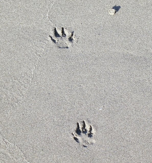
Raccoon Feet; and Garnet Sand (Click for larger image.)

I had Philip Whalen's voice in my head all day, as he wandered the main path at Tassajara more than thirty years ago, coffee mug in hand on a spectacular sunny February day and offering his very best T.-S.-Eliot-as-an-old-man impersonation. "Midwinter spring is its own season," he creaked, passing by.

Thank you, Phil; and thank you, Olympic National Park.

Second Beach, before the fog moved in, and after. January 20, 2013

Saturday, October 06, 2012

Step Out Onto the Planet

October 2, 2012, part 1. We headed right back to the Outer Coast the next morning, just PG and me. Destination, Second Beach. It's a hike-in beach, not a drive-to. The trail is through second-growth forest, lavish enough in the morning light. Trees like to grow here.

Trail to Second Beach (Click for larger image.)

You go up a bit, then down down down the steps to the beach. There is always a greater or lesser pile of logs to be crawled over to get out onto the sand. Lesser, on this day. PG & I are short people, I was glad there wasn't a serious log barrier. Without too much trouble, we stepped out into the gorgeous space of Second Beach.

... (Click for larger image.)
Second Beach, October 2, 2012. Soundscape for Cee.

The beach is sandy, broad and flat, very unlike Rialto. The tide was coming in, plenty of whitecaps out there, but it rolls ashore in waves only inches deep almost everywhere. Note the 'almost'.

... (Click for larger image.)
Incoming Tide. Soundscape for Cee.

We ambled south. There was a subtle show of garnet sand,

Garnet Sand (see explanation) (Click for larger image.)

There was a dead bird with really big beautiful wings. No eagles, not really even gulls. Where were the fish that bring the birds, if you please? It kept right on being sunny and beautiful. There were itty bitty flitty birds at the back of the beach; PG studied them carefully: savannah sparrows. There was a large chunk of marine debris, a 5-foot tall chunk of styrofoam partly encased in concrete. Huh? The tide kept coming in.

Styrofoam in concrete. Winter tides are going to break this up and strew it all over the pristine beach, but it's too heavy to move... (Click for larger image.)

Eventually we thought to head back, and found our inches-deep waves rolling right up to the sea stack tucked back against the hill. This pinchpoint had caught all the logs which were no longer at the foot of the trail. Our choices were to get wet in front of the rock, or go around behind— crawling over the field of logs. We opted for the log crawl.

Note the wave washing the log in front of the rock (Click for larger image.)

As we came out through the log field we saw that a couple was watching us. They called out that they had opted for the water route. We were afraid of that one, we said, but this wasn't too much fun either. We saw you down the beach, they said, and wondered which way you'd go. They waited until we were safely back out on the sand, then started back up the hill, as did we shortly behind them.

(Continued in next post. The title of this one is from a poem in Lew Welch's Ring of Bone.)

Sunday, June 05, 2011

Second Beach, Minus 1.5 Tide

Parasol weather on Second Beach: bright sun, endlessly retreating tide. Before I even had my hiking boots put away and water shoes on, I heard an oyster-catcher, and he kept on calling. There he was: the clown, the goofy shore-bird who looks like a cartoon.

Meet Mr. Oyster-Catcher, Second Beach, June 5, 2011 (Click for larger image.)

At lowest tide

Arriving Waves, Maybe 2 Inches Deep (Click for larger image.)

many people ambled over to look at Crying Lady Rock from what seemed to be the shallowest point, to see whether they could make it over to the island. Some years you can actually walk right over to it on the big minus tides of summer. (1). So enticing: caves, tide pools, and if you could just get over there you could by golly walk right around it with the tide this low. Only two boys actually got across the channel. Myself, not having anyone to leave my daypack with (and not knowing how deep it was going to be) I turned back when the water was up to my thighs and I could feel the current pushing. Later I saw the boys on the trail. They said the water had been chest deep in the channel, and the island's tidepools were very cool: crabs, seastars, anemones, a sea cucumber.

You can't walk dry-shod to Crying Lady Rock this year either. Note the oyster-catcher there near the gulls. (Click for larger image.)
Panorama, Second Beach on a Sunny Day, June 5, 2011
Another Panorama (the camera is full of them), Second Beach (Click for larger image.)

I didn't stay long, it was relentlessly bright and after I'd somehow gotten sunscreen in my eyes I could barely open them against the glare. Retreated back up the trail into the shady forest.

Trail to Second Beach, about 8 AM. It goes up a bit, then mostly level... (Click for larger image.)
Then drops steeply to the beach (Click for larger image.)

The Park advocacy group Olympic Park Associates worries, by the way, that the south parcel of land which the Park is handing over to the Quileutes lies immediately above Second Beach, and that the tribe's development of this parcel may create light, noise, and visual impacts for the Park's wilderness users at Second Beach.

Reminder map:

Friday, May 06, 2011

Changes Coming in the Place I Always Go

A bill has been introduced by our Representative, Norm Dicks, and our Senator, Maria Cantwell, regarding land transfers from Olympic National Park to enable the Quileute to move the school and senior center and certain other buidings up out of the tsunami zone. This is a process which began long before the recent tsunami in Japan, and events have made its importance clear. There are news stories (1) (2)(3) (4) (map). The school in particular is right on the beach at the edge of the world. It's the building with the blue roof.

This is a map from Handbook of North American Indians: Volume 7—Northwest Coast, published by Smithsonian Institution Press, reproduced here with permission. Notice along the left edge, the dark spots representing present-day reservations of the Quileute and Hoh tribes.

"Fig. 1. Territory of the Quileute in the mid-19th century" from page 432 (Click for larger image.)

Next, below, is part of a map kindly sent by Olympic National Park, showing an overview of the area in which land is being given to the Quileute tribe to move some parts of the tribe's central area out of the tsunami zone. I have somewhat tilted and cropped the map in a not-very successful attempt to make it show the same area as the 19th century map above. (The original unedited map is here.) Notice along the left edge the circle enclosing the area of the present Quileute reservation and the 780 or so acres which are being shifted or redesignated. (The Hoh Reservation is also making moves to get itself out of the tsunami zone, but not in this bill.)

About the same area on about the same scale, location of the areas covered by the Bill (Click for larger image.)

Here is what they are planning to do in that tiny area on the far western edge of the Quileute's one-time territory. The tribe gets back some land, and in exchange they agree to permanently and formally allow access across reservation land to the National Park's lands at Rialto Beach and Second Beach. (There are lots of other complications in the bill.) Thank-you to Olympic National Park for sending this map also.

Olympic National Park Proposed Boundary Revision (Click for larger image.)

OK then. As you know, I go to Rialto Beach most often, and sometimes in whale season to First Beach on the reservation at La Push, and sometimes to Second Beach. I'm going tomorrow. Maybe it's not too late in the season to see or fail to see gray whales at First Beach. Maybe I'll do this month's beached-bird survey at Rialto.

How You Get From the North Side of the Quileute River (Rialto Beach) to the south Side (La Push) If You Don't Have a Boat (Click for larger image.)

Just as a reminder, the whole of my beach life takes place in this small bit of the Quileute's original territory.

Sorry for shortcomings of graphics skills, and any errors in telling things clearly. I've left out all the history. Not mine to tell. But I have my own relationship to the territory.

Sunday, June 13, 2010

The Minus Tide

Although I'm now older than dirt, and more inert with every day that passes, certain kinds of geographical questions will still push me to considerable efforts. Some things I just have to know... Up at 4AM this morning. The goal was to be out of the house by 5AM, and on the trail to Second Beach by 6:30AM, just in case this morning's 8:10AM minus-2.3 tide made it possible to walk out to Crying Lady Rock (on March 6)(on May 30).

So away I drove in a beautiful nearly-sunrise morning, and out to the gray slightly drizzly West End. I was only a few minutes behind my planned schedule, threaded through the surprisingly gloomy forest, and was down on the beach by 7:35AM. The tide was already astonishingly low. Yes you could walk on the bottom of the sea, walk walk walk far out towards a horizon full of sea stacks, until you could easily see everything from an entirely different angle. The waves were washing in an inch tall the way they do at low tide on such a flat beach,

but no, not enough sand has been brought back onto the beach by summer conditions to make a walkway to Crying Lady. A moat of water around it still, which I hadn't the nerve to try to cross. Not me, nor any of the other walkers...

No pictures. The camera wouldn't turn on. Metaphysical catastrophe: is a day happening if I can't take a picture of it?

Put the camera away, pulled out the binoculars. Thought I saw a line of pelicans, flying north, way out to sea. Silhouetted cormorant. Eagle action, including one who was apparently building a nest up on Crying Lady Rock somewhere; came sailing in with a twiggy branch in its talons and disappeared into the trees on top of the rock. Would that have been Mr. Eagle or Mrs. Eagle, or do they both furnish the nest??

I wandered around on the bottom of the sea for a couple of hours, then ambled back up the trail. OK, truth, less than two hours. Having the camera broken made me antsy to get home to find out what was wrong with it, and I was mostly satisfied already. And sleepy. So I headed home.

A couple of rangers came down to the beach as I was leaving. I asked one of them if there was any likelihood that by the next month's minus tides there might be more sand, enough to walk out to the big rock. He said probably not, 'it looks like we've had some erosion'... Which is a non-answer, more or less. He did not say, 'no, because by June the beach is what it is going to be for the summer'. I think he didn't know.

Monday, May 31, 2010

Second Beach, Rain Rain Rain

Much to tell, but I wore myself out, and have Things To Do this morning. Here only the headline news: Did reach the ocean in time for the -1.3 low tide but you still couldn't walk out to Crying Lady Rock.

Second Beach, May 30, 2010

The Kalebergs have pictures taken on a -0.9 tide day when there was enough sand built up on the beach to make a magic sandbar that you could walk dry-shod out to the rock. (The 07/09/08 entry at the bottom of the page) So it's not just tide. Also depends on the beach profile. I'll keep trying. There's -2's in June and July, but even earlier in the morning alas... Still, the tide was plenty low enough for wonders.

Pisaster ochraceus, Second Beach. (Click for larger image.)

It rained all day.

Saturday, March 06, 2010

A Day Full of Answers

On Second Beach, Saturday. Can you walk out to Crying Lady Rock when the tide is low? Not when the low is around a zero (0.8 feet yesterday). Will have to try again with the big daytime minus tides of summer.

But the waves come ashore in their flat-sandy-beach way, a half-inch tall and gentle to the max. It feels like you could walk outward forever.

The logjam wasn't so scary and humiliating this time; without a companion hovering over me solicitously, I just merrily crawled and slid my way across.

There were eagles. You could hear them calling, see them sitting around on skylines.

The Small Arch in Quateata, north end of Second Beach. Note the eagle... (Click for larger image.)

Oooh, look, Washington Coastal Geology between the Hoh and Quillayute Rivers is online. Thank you, Washington DNR.

Monday, February 22, 2010

Rialto, Rialto, and Second Beach

We got in enough walking time for M. on Sunday by going to two beaches, first back to Rialto and along to Hole in the Wall (where I had been the day before, doing the February survey for COASST); then drove around to the trailhead for Second Beach, hiked down and walked that one.

Talked the whole time. Spectacular weather. We were very Happy and Contented, and I am very sad she is leaving.

The tiny person in the Hole in the Wall picture is M. heading for the further beach. I started back at my ambly pace; that way when she caught up to me she had had a good leg stretcher along the beach, and we had time for our chapter 2.

Hole in the Wall, Rialto Beach, February 21. (Click for larger image.)

Second Beach is spectacular. Thankyou to the Kalebergs for reminding me to go there.

... (Click for larger image.)


There is a huge log jam at the foot of the trail. Getting onto the beach and off again is extremely fraught with whining and instability (for fat old me). I ended up crawling over logs where everyone else was stepping confidently, and strangers kept offering to help me. I want to be young again.

On an amazing sunny warm day in earliest spring (and in a National Park), you have to share. Many many people on the beaches, even the walk-in beaches like Second Beach. That's ok. Better that people know and love the beautiful places.

Footprints on Second Beach. (Click for larger image.)
At Hole in the Wall, February 21.
At Second Beach, February 21

Wednesday, August 15, 2007

Second Beach

The trail to Second Beach at La Push. Second and Third Beaches at La Push are part of Olympic National Park; but not to be confused with Beach 2 and Beach 3, also part of the Park, further to the south near Kalaloch.
There were a lot of people down there, families and small children, and tents pitched at the back of the beach. Along the beach, sea gulls and pelicans and bald eagles were working some flock of fishies just beyond the sand. Between assaults the eagles were standing around on the strand pretending to be sea gulls... Click for larger image.