Monday, November 29, 2010

It's Still Yesterday In My Mind

November 28. As I said yesterday, it's always the same place. Only the weather changes, and the tides, and the surf, and the shape of the beach. OK, so never really the same place.


Reminder to self: here the earliest sunset arrives on December 7. It's nearly as bad as it gets. I gave this news to the checker at the supermarket, and the woman in line behind me. They were both pleased.

Always the Same Place

Sunday, November 28, Rialto Beach. No eagles or any birds very much at all except corvids, and little flitty birds near the parking lot. The beach swept clean, all the wood and small amounts of wrack are pushed back to the edge of the forest. The tide was just past the low (but not a very low low), and coming back in.

... (Click for larger image.)

Sat on various logs and watched, and read. I love to watch the foamy edge of the water shoot up the beach face in curvy swashy forms. (But almost all the pictures have horizons so tilted they are not usable...)

Still not much surf, despite the recent storms and another approaching. It would be nice if I understood about the direction of the winds and its effect on the size of the swell. Also be nice if I understood the basic geometry of forces that makes the minus tides all happen in the dark all winter long. We all know it's so, and not just because there's so many more hours of dark :-( It's very hard to plan winter beach surveys for COASST; but WHY?

When I arrived, hardly anyone around. Later more people had figured out it was sunny on the beach, and magically appeared.

Sunday, November 28, 2010

It Looks OK To The West (Webcam Tour)

The camera at Lake Crescent is down this morning. Milepost 237, the webcam at Indian Valley:

Milepost 214: the webcam at the DOT's Heckelville shed

First Beach:

Heading west soon.

(And up on top:)

Wednesday, November 24, 2010

Inchon, South Korea

The log shipment sailed about 6:30 this evening. Portland Bay is en route to Korea.

Off Jordan River Right Now... (Click for larger image.)

We Are Not Used to Weather Like This

Monday it stormed like crazy, wind and blowing snow, more and more snow, 8 inches maybe around here but who can tell because the wind swept some places clear altogether and piled it up elsewhere and there were no undisturbed places to stick a ruler in. All the streets were iced over. Everything closed. Tuesday was sunny gorgeous all day but freezing cold, and streets will remain iced, mostly, until the end of the week if/when we get warmer weather and rain. Everything still closed.


Tuesday Dawn Clear and Cold, November 23, 2010 (Click for larger image.)

For the record let me say we had the snow/ice/bad-roads-for-days combo only once before since I moved here, during my second winter. Barely a dusting last year. It isn't normal, which is why the city is not equipped to keep up with conditions which in the Northeast and the upper MidWest scarcely even count as weather.

Late morning Tuesday, I drove cautiously down to the harbor to see what Portland Bay was up to. (Loading again. Later I'll make a separate post.) Then home again without the rest of the errand round, the streets were not inviting... In the late afternoon I put on my yaktrax and stomped down the iced roadway to the park bench at the end of H Street, looking across the papermill, Ediz Hook, the Strait. This was so rewarding...

Victoria, BC, Across the Strait, from the Foot of H Street Up on the Bluff, November 23, 2010 (Click for larger image.)(Do click, downtown Victoria is very clear...)

...I stomped on along to the east, peeking out between the houses on the bluff until sure enough, there was Portland Bay at her moorage down below. It was not yet 4 o'clock, but they were no longer loading. From the distance, it sure looks like they might be finished.

Portland Bay from the Little Park on the Bluff at the End of E Street, November 23, 2010 (Click for larger image.)

Wednesday oh my word it is snowing again, gentle flakes hardly worth mentioning except I feel less housebound when I can see the driveway is dug out. Schools, libraries, my workplaces all still closed. 23° at the moment, warmer than yesterday afternoon during the clear weather. Eventually traffic will have sort of warmed the main-traveled roads and I will declare the day cautiously drivable; need to get to the library, for one thing. Need to get out out out of the house.

This could all be better timed. I am not my own best company right now, and I can't get to the ocean.

Sunday, November 21, 2010

Sunday It Snowed

Very very quiet at the log terminal. No trucks, no workmen's vehicles, no securing guard in the shack. Buffleheads and hooded mergansers paddlin' around in the water.

Portland Bay (Click for larger image.)

It's good I didn't go to the coast. First Beach itself doesn't look to have gotten snow, but there are places between here and there that get icy given half a chance.

The Department of Transportation camera in Indian Valley (Click for larger image.)

Wait.

I'm going where??

Wonder How Long This Will Take To Pass By (Click for larger image.)

Very Dang Cold

I gotta go to the ocean. I seem to be hanging around waiting for the frost to melt off the car windows. That won't work. On the other hand, the roads are probably still icy through Indian Valley and along the Lake, so there is a certain value to waiting a while for traffic to warm the roadbed.

The ocean will be very quiet. Whatever the passing weather systems are doing, they are not raising the swell coming to our coast.

First Beach webcam, November 21. (Click for larger image.)

Will detour to the log terminal before heading west, to see if anything is happening.

Friday Morning, Friday Evening, Saturday Morning

The logs are coming from Merrill&Ring's forest lands on the West End. This is according to David J. Sellars' articles in Peninsula Daily News; one in March about Portland Bay's sister ship, Koombana Bay, 'the first large ship to take on logs in Port Angeles Harbor in a decade.' Another in May about another log ship.

But why? Why now? And where are the logs going? Another article says Korea. Why? It should be possible to learn Portland Bay's destination port, if I don't lose track when she's out of range of marinetraffic.com and the other sites. Here is a nice picture of our Portland Bay, from marinetraffic.com.

Friday morning before work. A security guard cues me in that they are also loading rafts of logs from the waterside, and suggests I go over near the marina office for an angle on it.

Tug moving out with a raft of the remaining logs in the water, November 19, 2010... (Click for larger image.)

Ediz Hook (map) in the background of the image above, across the harbor. You can just make out the red speck of the pilot boat, and a large tanker passing by out on the Strait, just behind the Hook from this angle. Usually I take pictures of the harbor from out there, not from this side.

Loading from the wharf continues, November 19 morning (Click for larger image.)
Portland Bay and Alaskan Explorer, November 19, 2010 (Click for larger image.)

Friday evening. Visible progress. The load is approaching the top of the stanchions.

November 19, evening (Click for larger image.)

Saturday morning, November 20th. Nothing seems to be happening. A guy in a pickup teases me when I hop out of the car with my camera ("I'll take 8x10s of those pictures"), and tells me she won't leave for a couple of days, and that the load will go to the tops of the stanchions. I always believe guys in pickups.

November 20, morning (Click for larger image.)

Friday, November 19, 2010

Loading Portland Bay, part 2

November 18, late afternoon. Went right back after work. Visible progress. The holds had been filled, and water-tight covers put on. Tall stanchions were put up along the sides, and the loading continues. All four cranes are working, loading from trucks on the near side, from log rafts out of sight on the far side. (The covering of the holds, and the fact that they are loading from the waterside as well as from the incoming log trucks, I didn't learn about until the next morning.)

Where are these logs coming from? Where are they going? Why has the work in the woods suddenly started up again in the past year, after maybe as much as a decade? What's going on here?

From there I went out on Ediz Hook. It had clouded over. Crabbers were coming in to the small boat docks, all telling each other they had done very well. One lady told me they got eight big ones, two of them huge. She was going right home to cook them for dinner...

Small boat docks on Ediz Hook, Port Angeles across the harbor (Click for larger image.)
Port Angeles harbor, Olympic Mountains to the south (Click for larger image.)
Small crab boat on the Strait, Victoria on the other side (note Mt. Douglas) (Click for larger image.)

Loading Portland Bay, part 1

Wednesday evening. Dusk on Ediz Hook. Overseas Los Angeles was anchored out in the harbor. Alaskan Explorer at the terminal on the town shore. One pilot boat at the dock, the other out there somewhere.

Evening sky, November 17, 2010 (Click for larger image.)

Thursday, November 18. Went down to the terminal docks before work to get a picture of Explorer. Had to pull aside to let a log truck pass. Um, huh? Where's he going? Something's happening here. At Terminal 3, the Pacific Basin Portland Bay is being loaded with logs. Chains rattle. Great hollow clanking thumps as bundles of logs are lowered into the hold. All four cranes are working. Trucks keep arriving.

November 18, morning, Portland Bay (Click for larger image.)

I had to leave for work, alas.

Duration of Daylight/Darkness

New toy. Duration of Daylight/Darkness Table for One Year. Thank you, US Naval Observatory. From their Sun or Moon Rise/Set Table for One Year we get the annual happynews that earliest-sunset will arrive on December 7, so it's already darn near as bad as it gets. Sunset today, 4:31. In a couple of weeks, 4:20. Then it turns around.

Reader, it's different where you are. Use the tables.

A couple of times a year I fret about the assymetry... Quoting myself in May: Whenever the topic arises I look at the first analemma photo (a one year multiexposure photo of the sun at the same time of day), the one taken by Dennis Diciccio in 1978. I see the tilt. I sigh and say, ok, I get it, just for a thought-moment.

Wednesday, November 17, 2010

I'm Not There

The sun is shining at First Beach. I'm not there. More storm coming.

First Beach Webcam, November 17, 2010 (Click for larger image.)
Weather radar at the moment, November 17, 2010 (Click for larger image.)

Divination

There's a real shortage of shipwatching in my life lately, so trying to figure out whether it might make sense to go down to the harbor after work today. Er. Possibly not.

Monday, November 15, 2010

Neoesperiopsis

Under the sea/ under the sea/ darling it's better/ down where it's wetter/ take it from me.

Sundry websites sort of look right for our sponge, but not exactly: (1)(2)(3). Glove sponge Neoesperiopsis digitata , or Orange Finger Sponge Neoesperiopsis rigida. Maybe. Emeralddiving.com thanks Andy Lamb for identifying their glove sponge. I looked in his book. Andy Lamb says that rigida is branched apically, and digitata is branched laterally. Had I known to notice (and had any idea what it means), I could have looked more closely, or at least taken a better photograph.

Neoesperiopsis, probably

Beginning to see invertebrate life as it washes up on the beach has made the ocean three dimensional for me. I'm still a beachwalker, but everything I see is just the skin of the ocean (as landscape is just the skin of the earth once you start to learn geology). Down there in the underneath—under the view, the waves, the birds in the air or paddling the surface; deeper than the creatures in the upper tidepools, who are after all still or anyway sometimes on the surface—amazing creatures are living on underwater ground invisible to us.

This post is for Sebastian the crab. Or perhaps for the late Howard Ashman, who wrote his lines.

November Beach Survey

There are eagles around. One over the highway near Bear Creek, where in fact I think he must live because he's often there. Two very vocal eagles over the beach near the leaning ghost tree, four over the river (two mature, two juvenile).

James Island from Rialto Jetty, November 14, 2010 (Click for larger image.)

This time the Rialto Jetty beach segment was completely swept clean of either wrack or litter, and it was the Ellen Creek beach segment that had wrack, a mix of seaweed and animals. There was not much marine debris, except along one stretch south of the ghost tree there were a number of plastic bottles which had been nearly reduced to stiff lace.

Fresh Wrack Swept Back Among the Drift Logs (Click for larger image.)
Not A Clue. A Sponge Maybe??? (Click for larger image.)

On the return leg of the survey you count human traces. Coming back from Ellen Creek, 18 people on the clicker and two dogs, though for much of the walk the beach was doing a good imitation of being completely empty. By the time I was coming back from the Rialto Jetty beach segment, no people no dogs, the first time ever that I have put 0/0 in my survey notebook. It was raining again at that point, but that doesn't usually keep people off the Park's premier drive-to beach.

The Leaning Tree Hasn't Gone Over Yet (Click for larger image.)

No dead birds to write up. If there were any, either the set of the waves had carried them away or they were buried under the sand and pebbles.

Walkers (Click for larger image.)
Empty Beach (Click for larger image.)

P.S. for COASST: on the Rialto Jetty beach segment there was a small amount of persistent foam of the sort that leaves a gritty brownish residue. It was just to the south of the access from the parking lot. Nowhere else. Click for larger images.


Sunday, November 14, 2010

Heading Out

Heading out for this month's beached birds survey for COASST. Very much hoping that today's data points are the absence of dead birds to identify.

Thursday, November 11, 2010

Long Ago and Far Away

One of the implicit ground rules of this blog is immediacy, but I need to tell/show something about the Bosque del Apache National Wildlife Refuge in New Mexico. None of these photos bear on my here-and-now life, except to explain why I arrived at Ridgefield NWR on Saturday with expectations, and except that all weekend long I was remembering trips to the Bosque, and the friends I have been there with. Mentally composing emails to various of my beloveds as I drove: 'I took a road trip. You were on my mind.'

I think this is the population of greater sandhill cranes (subspecies Grus canadensis tabida) that breeds in Idaho, stages at Monte Vista NWR in Colorado, and winters on the Rio Grande. They don't travel very far, relative to their cousins that come down the coast, or the ones that stage in Nebraska. Photos from 2003, 2004, 2006, and unknown years like that.

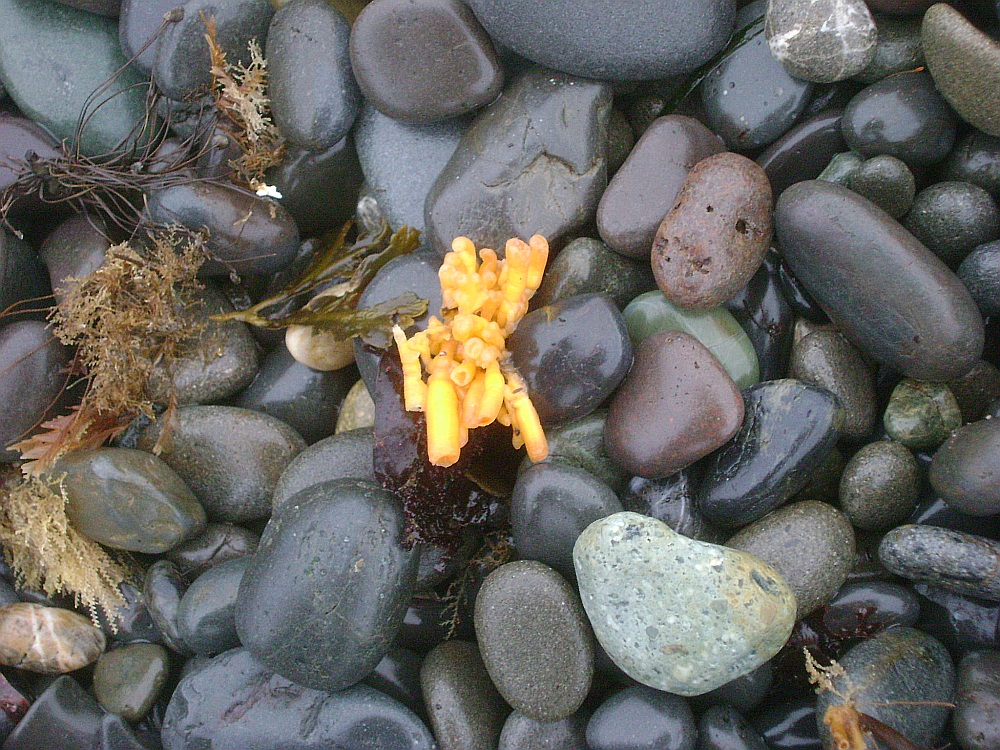
Sandhill Cranes at Bosque del Apache, New Mexico, various years (Click for larger image.)

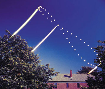
Just before sunrise on Flight Deck, December, 2006. Temperature about 5 degrees. Parts of the ponds were well-frozen, the birds walking around where they expected water, and skidding when they landed.

Watchers at Bosque del Apache, New Mexico (Click for larger image.)

There are also snow geese in (what feels like) Pleistocene plenitude, and by the numbers even more ducks. (Jeez. 80,000 ducks in the winter of 2005/2006. 55,000 geese some years. 15,000 cranes.) The Bosque is where PG taught me that ducks could be told apart, beginning I think with the altogether elegant Northern pintail (image)...

Snow Geese at Bosque del Apache, New Mexico (Click for larger image.)

OK, I think our cranes that come down the coastal arm of the Pacific Flyway are canadian sandhill cranes, Grus canadensis rowanii. Is the subspecies difference enough to explain why the Bosque cranes largely ignore people, feed in fields and yards all up and down the Rio Grande, while the Ridgefield cranes are so shy that visitors are not allowed anywhere near where they roost?

This post is for SP, who pointed out the flight of sandhill cranes over the Pacific Ocean when we were on Hobuck Beach on the Makah Rez. And for PG, RM, MS, SA, KB, IJ, LB, IR, GF, PB, RF, DG, MP, & UG, with whom I have watched at the Bosque on one trip or another; and for our neighbor JL who first told me about it, our second winter in New Mexico...

Note how those Mid-Continent Population cranes that breed so close to ours pass through Nebraska (up to half a milion of them) (Click for larger image.)