Thursday, September 30, 2010

Pause

The sun did a cheerful red rise a little while ago, still crossing the horizon where I can see it. In a couple of weeks and onward for several months it will be popping up behind the trees in the vacant lot; and also too far south to shine in the front windows again until late February or early March. For some reason it charms me all to pieces when the sun comes obliquely in the front windows, which I think of as facing north though in fact the angle is more like 25 degrees east of north.

It's really blue out there. Maybe after work I'll rush out to the west and watch the salmon jumping on the Sol Duc River. Could wait until tomorrow, I'd be leaving from Elwha instead of the college, half an hour further west; and in clothes I'd be more willing to play in. The Park biologist said in the paper this weekend that the coho salmon will be jumping at Salmon Cascades for the next month. But I can't get over the feeling that I'm missing my chance to see them. Jump. Jumpjump.

Wednesday, September 29, 2010

Blue Again All Over

Went down to the harbor to see if any ducks have yet come back for the winter. Not. But lots of blue water and blue sky and warm sunshine when I got out onto Ediz Hook (map); kayakers and a few fisher boats coming in, a seal by the docks. The 5:30 ferry was just pulling in when I got out there. The cargo ship Port Philip is anchored out in the harbor, being fueled. On the Strait, one big ship outbound over towards the Canadian side, and after that not a single ship on the move.

Strait of Juan de Fuca. On the far side, Vancouver Island (CA) to the left, San Juan Islands (US) to the right. (Click for larger image.)

Then the water taxi Sealth Arrow came across the harbor towing a long floating dock. After sunset she came back with another load, several shorter docks rafted together. They will be hauled out into the parking area near the end of the Hook for the winter, out of storms' way. It happens every winter, but to tell the truth I don't know where they are brought in from. The city pier? The marina? There were just two guys, one driving the Sealth, the other climbing around and shifting ropes and manhauling the incoming pieces into position, then lashing them on either side of the more westerly of the small boat docks.

The first dock-moving run (Click for larger image.)
The second dock-moving run (Click for larger image.)

Meanwhile several small recreational fishing boats puttered in past all the activity and along the dock closer to the pilot station; loaded up on their trailers; and headed home.

Tuesday, September 28, 2010

What Cliff M. Said

Peering through the windshield wipers into light rain and thick misty air yesterday afternoon, somewhere west of Pillar Point. "It's really wet," I said, "the road is wet, the air is wet, everything is WET..." Yup. I can't make out whether Cliff Mass's startling water vapor image from ssec.wisc yesterday is ok to borrow (go take a look at it), but today's GOES water vapor image sure belongs to us all, thank you NASA...

Warm River of Water Vapor (Click for larger image.)

Monday, September 27, 2010

Proper Respect and a Place in the Scientific Record

It only rained half the time, it was very warm, it is always beautiful. COASST survey at Hobuck Beach. There was some distressing-looking brown foam accumulating, perhaps evidence of a continuing algal bloom; but only a dozen or so birds to work, normal for that beach, so still no wreck in progress.

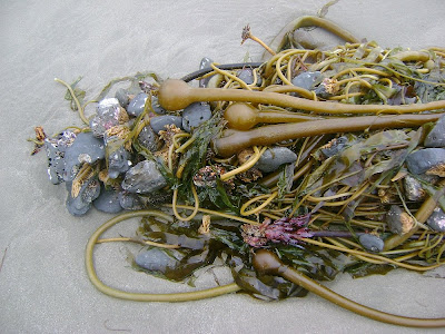
Shells, sand dollars, seaweed of all sorts and especially more heaps of kelp washed up by the last storm than you can imagine. It must have been some storm, tore out whole swathes of the kelp forest, rolled them and braided their stipes and washed them onto the beach, their holdfasts still gripping an entire geologic sample of their former undersea home...

Nereocystis luetkeana heaped on the shore at Hobuck Beach (Click for larger image.)
Nereocystis luetkeana holdfasts gripping rocks (Click for larger image.)

JL and SP and I were field-training four potential new volunteers for COASST. None too competently, but we managed. I have a nice photo of five of us standing around a (dead) white-winged scoter, giving it proper respect and a place in the scientific record. But the image shows the new people, and I don't have their permission...

Gulls. Rain. Seaweed. One sweet little sanderling (I don't get shore birds at Rialto, always love to see them). An astonishing, drop-dead gorgeous immature bald eagle crossed the road right in front of the windshield on the way home. Altogether a fine wet day.

Here:


View Larger Map

Sunday, September 26, 2010

High Surf Advisory

Saturday was a having-it-all day: high tide with storm surf for a few hours, then some charismatic fishes leaping up the Salmon Cascades, then a terrific bird talk with an identification for the September 5 mystery-birds.

It was supposed to be a space between storms, cloudy no rain. And the high tide only a 7.1. 'Oh,' thought I, 'I will go to the beach, take a walk, and then sit and read.' But the moment I came around the curve where you first can see the ocean, I understood there was a flaw in the plan: surf breaking way out, and lots of foam (and also rain).

Oh storm surf, how could I have forgotten about you. #bigswelladdictagain http://twitpic.com/2s0gx0about 20 hours ago via Twitpic


Pelicans, too. Any day with pelicans in it is already a good day. But I got tired of pitching the camera up at the wet sky or out over the waves and pushing the button without much hope of success. Blurry waves and microscopic pelicans. So no pelican new pix.

Rialto Beach, September 25, 2010 (Click for larger image.)

(I checked the NOAA warnings when I got home and there was nothing, but today they tell us it's still surfy out there:

...A HIGH SURF ADVISORY HAS BEEN ISSUED FOR THE NORTH AND CENTRAL WASHINGTON COAST...WHICH IS IN EFFECT UNTIL 3 PM PDT THIS AFTERNOON. SEAS HAVE REACHED 15 FEET AT THE CAPE ELIZABETH BUOY THIS MORNING. THIS IS THE HIGHEST THE SURF HAS BEEN SO FAR THIS SEASON."

So I spent a couple of hours watching, sitting on first one log, then another higher up the beach, then another. A lot of other people were doing the same, not always being careful. Some people came along the beach who had gotten caught in a wave up to their waists.

On the way home, I detoured up the Sol Duc River to see if the salmon were jumping. I assumed not, as there didn't seem to be much water in the river at the highway crossings, but I thought I'd go see with my own eyes, and anyway the forest is very beautiful there. There actually was a cheerful plenitude of water in the river at Salmon Cascades, and by golly the coho salmon were jumping. Not too many. Jump. Wait. Jump.

Sol Duc River at River Mile 59 , September 25, 2010 (Click for larger image.)
The Forest at the Cascade (Click for larger image.)

Decided not to try to capture a fish in flight with the camera. Too hard; pretty soon you stop seeing them as charismatic embodiments of life at its most determined, and instead see only one missed photo op after another. So I just watched. This one from last year will do, no?

A Coho Salmon on October 18, 2009 (Click for larger image.)

In the evening, Barbara Blackie's talk at the Feiro about Olympic Coast birds. She talked about our own familiar critters, common murres and auklets and puffins and murrelets and sooty shearwaters. I was looking out the window at Jupiter rising incredibly bright over the Strait, when I heard her say something about 'tens of thousands of sooties'. Immediately I thought of the flocks of mystery seabirds that had been on and over the water north of James Island at the beginning of the month. I asked after the talk, and sure enough she thinks my skillion floating and flying seabirds were sooty shearwaters, she heard there was a shearwater event on the outer coast earlier this month.

I just KNEW somebody would know, disgraced myself by asking the impossible question ('please tell me what did I see even though I couldn't see clearly enough to describe it to you') over and over until someone knew the answer.

The NOAA folks at the talk said that although there was an algal bloom in progress offshore, there was so far not a mortality event. I reported I had seen a whole lot of latte-colored foam stirred up by yesterday's swell. If there is a wreck, it probably won't be scoters, they are finished molting and can just leave (which last year they could not).

Thursday, September 23, 2010

Just Like That

Immediately it's another season. There is the sound of rainy streets briefly in the night; and suddenly it's nearly time for the coho salmon to be jumping up Salmon Cascades on the Sol Duc. I woke up thinking, 'Probably not enough river flow. Yet.'

The water year ends a week from today. I went touring the watery data websites for the first time in months. The Elwha River jumped up when it rained last week (1). And look at this: for 2009/2010, even with our dry summer, precipitation here (but only here) was 125% to 150% of normal.

Basin Precipitation Map, October 1, 2009 - September 23, 2010 (Click for larger image.)

On a whole 'nother topic, I don't need to go out this weekend to do a seabird survey on my beaches. JL from COASST says, "We've received around a dozen reports this week, from Neah Bay all the way south to Copalis, and no one has found anything out of the ordinary. No cause for alarm as of now...."

And yeah, opened the curtains this morning entirely aware that it will be six months before the days are again as long as yesterday was.

"Location, Location, Location"

The Feiro Marine Life Center is offering the 7th program in its 2010 Marine Science series. Here's the full announcement:

FEIRO MARINE LIFE CENTER ANNOUNCES 9/25 PRESENTATION - 7th IN ITS 2010 MARINE SCIENCE SERIES
At 6:30 p.m. on Saturday, September 25, 2010
     At the Feiro Marine Life Center (FMLC) located on the Port Angeles City Pier (Lincoln and Railroad)
     Speaker: Barbara Blackie, Peninsula College Instructor, who works seasonally on the coast as a biologist for Olympic National Park, has just returned from the World Seabird Conference, and
     Presents: "Location, Location, Location" - Seabirds and prime ocean real estate, our Washington Coast.
     Barbara's talk will cover the marine birds choosing our wild Olympic Coast because of the fantastic breeding and feeding opportunities found here. From charismatic auklets and puffins to graceful gliding albatrosses and shearwaters, seabirds have unique ways of thriving in extreme environs. Barbara's presentation on the natural history of coastal marine birds will highlight the life strategies of regional birds. She will also discuss some of the findings from at-sea surveys conducted through the Olympic Coast National Marine Sanctuary and review what is known about the 2009 seabird mortality event.
     FMLC is a 501(c)(3) organization dedicated to promoting marine conservation and education. A $5 donation is suggested but not required. To assure seating/set-up for this presentation, an RSVP is requested to reserve your space(s).
     To reserve/ or for more information, please call (360) 417-6254.

Do RSVP if you are going to attend. They'll move to a larger space if they know a lot of people are planning to be there.

Wednesday, September 22, 2010

Think of It This Way

Equinox. It's about exactness, and perfect balance.

At sunset today, the setting sun will cross the horizon exactly due west. All over the earth. I won't see it here, there are clouds; but still it's true. I check with my compass whenever I have clear weather on the equinox, and access to an unobstructed horizon for sunrise or sunset, and it's always true. Due east. Due west. True everywhere.

At 8:09 PM our time, the celestial equator and the ecliptic intersect. (No, I can't visualize it, but I know it's true.) At 8:09 PM our time, the axis of the Earth is not tilted toward or away from the Sun and the circle of illumination cuts through the poles. At 8:09 PM our time, it is the moment when the Sun is positioned directly over the Earth's equator.

Today, everyone on the globe has exactly the same experience of daylight: exactly as much light as darkness. This is not an occasion of sadness. This is... wow. Something like actual magic.

Having Wonderful Time, Wish You Were Here

Fall quarter has begun at the college. I'm back at work, hanging out behind the desk; helping people find things, yes, but mostly helping people do things. Reconnecting with colleagues. Readin' professional stuff again. After this first busy week, must re-orient to the off-desk activities I left hanging at the end of spring quarter.

Back in the day, librarying was a much larger proportion of my life, in fact, practically the whole of it. I thought about the library patrons' needs and the library's needs day and night. My colleagues were also my circle of friends. Back in the day, any of us who spent time at the reference desk at Santa Fe Public Library might very well have found one of Peter Taylor's drawings left behind on the desktop amid the scrap paper. Sketched portraits of the library-user-traffic passing to and fro in front of us. We used one of these drawings in the Poetry Broadside about ten years ago. Here's another:

Peter Taylor, ball-point pen on paper (Click for larger image.)

Much more than I expected, community college librarying is not all that different from public librarying. There are these people, mostly young, who need help and have nowhere else they know of to get it. Fewer crazies, fewer passionate readers like the population who used to come haunt the new books shelves every day; and less continuity of faces, as the students cycle through the community college and move on. But it's the same work, really, and I'm so glad to still be able to be doing it, here where I want to be. Only, I miss my friends.

Saturday, September 18, 2010

Days Are Scrolls

"Days are scrolls: write on them only what you want remembered," Bachya ibn Pakuda, 11th century (copied out of the prayer book this morning). I'm in Florida, the usual mis-planned family trip.

I'd rather think about home:

On the ferry home from Vancouver Island last week I saw a humpback whale.

OrcaLab has posted a blog entry about the A30s, the orca family we followed most of the day on the 11th. There's a gorgeous audio file included in the entry.

Decided the many small seabirds I saw flocking and floating early in the month could maybe have been auklets. No reason to think so really, but I'd rather think of them as Somethings rather than Unknowns. Update on September 25: Barbara Blackies thinks my skillion floating and flying seabirds were sooty shearwaters, she heard there was a shearwater event on the outer coast earlier this month.

Tim McNulty emailed that Nalini Nadkarni, the canopy biologist, says branches in the high canopy she cleared of mosses were essentially still bare ten years later. So I might have to stand several decades with my arms out to grow a moss curtain in the understory of the rain forest.

JL from COASST emailed that there is an algal bloom developing, and "there are white wing and surf scoters on beaches in the Kalaloch area. The majority were still alive, but there were also dead birds on each beach that she checked. We now have a similar report from the mouth of the Hoh River. We have no definite information about beaches north or south of that area." She asks all the volunteers who work beaches on the outer coast to go do a survey as soon as possible and report on conditions. I'm in Florida now, and working next week. Can't do my beaches until maybe Sunday next. By then it will already be known how large a 'wreck' is in progress.

Home Monday night. Back to work at the college on Tuesday.

Sunday, September 12, 2010

Road Day Up, Boat Day, Road Day Back

Friday trekked across the Strait on the ferry, and drove all the way up island to Port McNeill to rendezvous with friends. Saturday we spent on the Naiad. These are the A30s. We were with them most of the day. It rained.

A30s somewhere in the Plumper Islands, I think. (Click for larger image.)
A30s off Cracroft Point, OrcaLab's observation station in the background (Click for larger image.)
By this point in the day I had lost track of where we were. Someplace beautiful and rainy, no? (Click for larger image.)

Word is, a large group of orca are headed in from the west. Everybody will be back on the boat today, but I have to head home. Before the next time I do this trip, I'm going to have learned a lot more about Vancouver Island geography and geology, to keep myself entertained for the six hours on the road. Aiming for the mid-afternoon ferry. Yikes, gotta go.

Thursday, September 09, 2010

Wednesday Mid-day, Wednesday Sunset

One last hike with M., who is moving away. She wanted to go up the mountain. We went on the Hurricane Hill trail. Saw some deer, saw a marmot. (Saw a warning sign about cougars on the same sign post where two months ago was the warning sign about mountain goats.)

From Hurricane Hill Trail, September 8, 2010 (Click for larger image.)

We joked about the cougar warning all day. He'd come eat us, the grouse, the marmots, that lone hiker over there. He already came and ate all the goats.

Cougar Warning (Click for larger image.)

Stopped at the end of the Visitor Center parking lot on our way out, and sat on the wall for a long time, because once we left we'd be gone. Watched a family of grouse.

The Grouse Family Was Down There By the Two Trees (Click for larger image.)

At dusk I looked out the window and saw I had mostly missed a sunset. Later there was a thunderstorm in the dark. It's really not fair: dark already at 8 o'clock...

Sunset, September 8, 2010. (Click for larger image.)

Tuesday, September 07, 2010

Any Day With Pelicans In It

On Sunday I went to the ocean. There were a great many people there, and a great many small birds sitting out beyond the surf line near the south end of the beach, and flying back and forth out there. A lot of gulls and pelicans too, the gulls really quite excited; and one presumes a lot of small fish under the sea just there for everyone to be eating.

A Lot of Birds All Very Excited (Click for larger image.)

The people with binoculars were all asking each other who the excited small sea birds could be out there, and none of us knew. Not a serious birder among the lot of us. But it was very beautiful. Update on September 25: Barbara Blackie thinks my skillion floating and flying seabirds were sooty shearwaters, she heard there was a shearwater event on the outer coast earlier this month.

Any day with pelicans in it is a good day.

Pelicans (Click for larger image.)

I was there to do the monthly survey looking for beached birds for COASST, and indeed had the first bird carcasses on my beach since last November. They were both in the wrack line, both large immature gulls. Though I had no survey companions, I called out "Bird!" firmly though not very loud, to summon my wits since I couldn't summon people who know more than me about identifying dead birds.

Procrastinating about entering the data, the birds' measurements and so on; and really procrastinating about cleaning up and tidying the bird pack, sorting out the tools. Left alone with a dead bird I immediately become confused and my rubber glove discipline inconsistent (or nonexistent). The pack is sitting here full of psychic dead bird cooties.

Saturday, September 04, 2010

Westward a Bit (Road Day #4, continued)

(Visit, completed) Still Wednesday. We headed a little further west along the shore of the Strait, to Salt Creek. (See map in previous post. This is point E.)

Kelp bed at Salt Creek County Park, September 1, 2010. (Click for larger image.)

Some people at the bottom of the steps at the Crescent Bay end of the bluff were looking intently at Something. I asked the lady with the binoculars was she seeing whales. (Could conceivably be gray whales...) But no. Turned out to be black oyster-catchers, oh bless their bright red stabby beaks and ridiculous pink legs. That party of people left, so we settled in on the rocks, declared it our dining room, and shared our second sandwich. Another party of people stubbornly picked their way out towards Tongue Point even though the tidepools were nearly covered, and accidentally startled away the oyster-catchers, who flew off in a chorus of whistles. Later they flew back. Later still, a kingfisher.

The View from Our Dining Room: Crescent Bay (Click for larger image.)

From here I suffered a #tourguidefail. Should have taken us all the way along the Strait to Neah Bay, to the true Northwest Corner. But we gassed up (and bought sugar snacks) in Joyce, and headed up the Joyce-Piedmont Road to intersect the northeast shore of Lake Crescent. Carried on west along East Beach Road to where the Lyre River ever so gently drains out of the Lake and starts heading for the Strait. (Point F on map). Explored a little pullout/path and found ourselves Right There by the river's start.

Lyre River (Click for larger image.)
Lyre River Flowing Out of Lake Crescent (Click for larger image.)

It was remarkably idyllic and pleasing. Will add this spot to future guest itineraries.

Thursday, September 02, 2010

The 'Freeing the Elwha' Tour (Road Day #4)

The storm blew on through, and Wednesday morning we set out to visit the dams. The dams on the Elwha River which are going away, you know. S. first wanted to see the college where I work, so the map (thankyou google) begins there:

Map for Road Day #4, September 1, 2010: (Click for larger image.)

The primary contract for dam removal was awarded to a Montana firm last week. And Lake Mills closed to public access on Monday for the next two months while subcontractors previously arranged for begin channel preparation for the flushing away of the sediments when the lake is gone for reals and forever. When we were back there Wednesday morning (Point B on map), swarms of Park ranger vehicles and subcontractor guy vehicles were hanging around getting ready to Start. They unlocked a gate to walk out on part of the dam structure, and let us go out there with them if we promised not to fall in. We promised.

Pictures can't give you a clue about how very tall and narrow Glines Canyon Dam is. Be sure to watch this animation of the Dam Removal Process...

Glines Canyon Dam and Lake Mills (Click for larger image.)

We stopped to take a look at Elwha Dam and Lake Aldwell (Point C on map.) All was peaceful there. Ugly. So ugly it's scary; this too will all be gone, for reals and forever.

Elwha Dam and Lake Aldwell (Click for larger image.)

For thoroughness we then went on to the where the river flows into the Strait (Point D on map). Here again there was sign of preparation work: the west dike has been rebuilt or resurfaced; the sweet riparian woods that overhung the near end of the dike road is straightened and graveled away.

Trail to the mouth of the Elwha River, on the west dike. (Click for larger image.)
River, Strait, driftwood, cobbles. (Click for larger image.)
Striped Peak, Strait, cobbles (Click for larger image.)

We sat on a log and talked a little about this huge industrial project underway to restore the Elwha River to a semblance of its original state, always supposing the ocean can manage to return the fabled salmon runs. It was early but we were hungry; we shared one of our sandwiches, and watched the waves break at the river mouth. This being the last day, I was starting to worry about not having yet manifested an eagle for S. to see. But as we were leaving, all the groups of gulls lifted off in sequence. There had to be an eagle scaring them into motion, and yes there was. There, there. See? Bald eagle.

The next thing on the agenda was Salt Creek Recreation Area. More in next post.

Pebbles in the Rain (Road Day #3)

Tuesday. Rain began in the night: the storm Cliff Mass promised. It was raining when we went to the diner for breakfast, wind blowing the rain aslant; raining as we headed back to Rialto, raining when we got to the beach. We parcelled out the rain gear between us as well as we could, and left everything else in the car; field guides, snacks, cameras.

We both got wet anyway as we wandered along, each filling a pocket with pebbles of our preferred size, shape, and color. Considering that all the stones on the beach were wet and they all looked smooth and dark, every one, I did very well. Arrayed on the kitchen table, they are WONDERFUL.

The ends of the beach were invisible in the rain cloud. We were by no means the only people out in the wet. People striding along in the warm rain, heading for (invisible) Hole in the Wall, whipping out their cameras for pictures... A line of pelicans appeared, skimming the nearest breakers. Absent any photographs, we'll use Willard Bascom's word picture: I think I typed this out last winter from The Crest of the Wave: Adventures in Oceanography, since it's definitely not in Waves and Beaches.

"...there were only low plunging breakers on the inner bar. Lines of pelicans moving down the coast would glide parallel to a breaking crest, gradually losing altitude until they reached the end of the collapsing curl. As it squeezed air out the end of the tube, they would be lifted by that jet and glide seaward to catch the next wave. They traveled for miles without seeming effort, using only wave power..."


We could have gone back to the rain forest, or tried to go down to Second Beach (OMG, imagine crawling over a slimywet log jam). We stopped at the pullout overlooking the river to think about what to do next, but wet as we were it was somehow not an attractive idea to squeeze something else into this day. We headed home.

Pelicans (Road Day #2 Continued)

Monday. After the elk we did four more things. Drove on out to the highway and into Forks. Stopped at the Twilight store so S. could buy a suitable souvenir for a colleague. (The store was not mobbed, which is a change from a year ago when I went in with PH & SA.) We had in mind for Tuesday morning to make the low tide at Rialto Beach so S. could pick up small pebbles, but the weather was still good and hours of daylight left, so we ignored the tide table and went to the ocean even though we would go again tomorrow.

Not a whole lot you can do at Rialto when the tide is high except sit on a log and watch and listen. There was fog to the west, quite close in, though we were mostly in sunshine.

Rialto Beach, August 30. 2010 (Click for larger image.)

Pelicans began to appear. Pairs of pelicans. Lines and v's of pelicans. They were angling in across the jetty towards the harbor at La Push, just out of sight over the jetty rocks. We began to think we would leave as soon as there were some more pelicans. And some more after that. Pelicans and pelicans.

We drove back to the Three Rivers corner and oceanwards again, to La Push. Dinner at the restaurant on the harbor. The fog moved inshore. Pelicans were wheeling by very close to the windows. I was hopping up and down in my seat, and showing my primate roots, hooting. "Ooh ooh ooh". No good photos. I should have had the camera make a little movie through the window. We consumed our really enormous portions of Quileute-caught salmon ("Out of Neah Bay?" I asked. "No, from our ocean right here," said the waitress) and watched gulls, pelicans, a seal or two (or perhaps a sea lion, it was hard to see characteristics but it seemed very large). There was a frieze of pelican silhouettes on the breakwater on the west side of the river mouth. (More hopping up and down and appreciative hooting. Oooh ooh ooh.)

Topo from topoquest.com (Click for larger image.)

We moved on to the end of the point, where you can look along First Beach in one direction, and out to sea past James Island in the other, the two webcam views (1)(2). (There were no Twilight tourists. I'm thinking all that is ebbing. Too bad for the TwiHard tourist industry which is presently supporting the entire West End.)

Looking West from La Push, August 30, 2010. (Click for larger image, there's a pelican in it.)
Pelicans in the Quileute River (Click for larger image.)
Pelican in flight (Click for larger image.)

Adjourned to our motel rooms in Forks, to be positioned for an early start for the low tide (not super low, but low enough) in the morning.

Wednesday, September 01, 2010

Forest (Road Day #2)

Monday. Off we went to the Hoh Rain Forest. Stopped at the Big Spruce Tree to change pace from highway mode to ambling-though-the-forest mode. The sign there said look for elk. We looked. No elk. We went on to the visitor center, carefully examining the roadsides for elk. No elk. Ambled around the Hall of Mosses loop. Watched a douglas squirrel energetically digging up bits of fungus and eating them right at our feet, shyness wasn't in it. Watched some kids decide a patch of Oxalis behind a big log were shamrocks and that they had found the home of the leprechauns. Read all the signs.

My attitude to the Rain Forest is perhaps insufficiently reverent. Under the bigleaf maples I reach my arms out and hold still for a while, wondering how long it might take for the moss curtains to begin to grow. Another gorgeous maple, my arms just naturally reach out again. Wandering though a grove of, um, big trees, I might just say, "You know, there's some really big dudes in here."

Bigleaf Maple with curtains of Selaginella oregana (spikemoss) (Click for larger image.)

Back at Visitor Center a little girl heard us talking about elk and she said they had seen one at the Big Spruce Tree. (I thought that meant we could count it as sighted wildlife. S. said no.) We gathered up the lunch tote bag and started around Spruce Trail loop. There was another douglas squirrel, this one on a branch right over our heads in the middle of the trail; he wasn't shy either. Picnicked by the river. No sign whatsoever of the promised rains.

Hoh River (Click for larger image.)
Colonade of Spruce and Hemlock on a Nurse Log (Click for larger image.)

As we were driving out, there were elk. Several cars were stopped in the road trying to photograph them. There were maybe six of them. By the time we could see them well, they were leaving. They're really big.

Elk by the road. (Click for larger image.)

The day continued ridiculously sunny. We decided to keep on in have-it-all mode and go to the ocean. More in next post.

Visit Road Day #1 Continued

Sunday. The Obstruction Point trip included other wildlife manifestations: chipmunks, deer along the highway and (especially) carefully examining all the cars at the Obstruction Point Trailhead, raptors out over empty space cruising the long drop to Lillian River, a report of mother bear and cub down by the little lake below the big stone steps (those we did not see; I say we get to count them, S. says not)(see PS below); a single raptor where the ridge was still narrow, who cruised up out of nowhere, skimmed across the road and down the other side, showing a white rump patch and must have been a northern harrier (the former marshhawk) though the habitat was all wrong. Some wildflowers left.

Still it was 'the marmot trip'; all the rest, including the vast sweeps of landscape, were just rolled into what in memory was a successful marmot quest. After the marmots, we went on to do four more things. A lunch in town: seafood by the harbor. Then on to pick blackberries from the roadside bushes behind the store at Laird's Corner. Since we were arriving on purpose with containers and a determined crew of two, I went in the store and asked permission. Which was cheerfully granted.

Then on westward, along the lake to the trailhead to walk on the trail to Marymere Falls. There was Barnes Creek, and some quite nice forest, and quite a lot of people speaking a good many different languages. We did not go up the stairs to the falls viewpoint, making do with creek and forest. There was some sun.

Barnes Creek Trail, 08/29/2010 (Click for larger image.)

Still the good weather was hanging on. On the way home we detoured down to Ediz Hook to look for ships and birds. There were a couple of big tankers in the harbor— a Polar at the terminal being worked on, an Alaskan at anchor — but no ship traffic on the Strait except a rapidly receding inbound ship. The pilot boat was just returning from having put a pilot aboard her. Some kids had found something interesting off the small boat dock. They got some sticks and went back out, the better to investigate. A couple of maybe cormorants, and gulls. No other birds.

Port Angeles Harbor (Click for larger image.)

*PS This makes sense as the little lake down there is surrounded by blue-leaf huckleberry, which goes conspicuously red in the fall, creating mysterious colorpatches all over the landscape— P. and I saw it that way around the lakelet a couple of autumns ago— and Tim McNulty says, "Black bears Ursus Americanus), are seen frequently in the high meadows in late summer, most often snout down in a patch of huckleberries." (p.77).

Tim M. also has pages and pages of loving prose about Olympic marmots. "One of the many traits I've always admired in marmots is their fondness for wide front porches..." S.'s iPhone maps our marmot photos as being here, which looks right. Ridge behind dropping into Lillian River. The front porch view out over the unnamed upper reaches of Maiden Creek...