Sunday, July 20, 2008
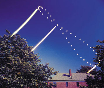
Daylight, Report on the Diminution of

Saturday, July 19, 2008
Canoes on the Move
My work email is filling up with messages about the movement of the canoes coming from the southeast corner of Puget Sound, already on the water. They're at Suquamish tonight. Port Gamble Sunday, Port Townsend Monday, Jamestown Tuesday, gathering more canoes as they go. We are expecting about 25 canoes, maybe 1100 guests including the support vehicles and families and elders associated with each canoe of pullers, on Wednesday evening. Protocol and drumming and dancing at the Tribal Center into the wee hours, but they will first land in front of the Red Lion Motel on Port Angeles Harbor, the stretch of shore called Hollywood Beach, where the village of Y'Innis was. It's the tribe's annual reminder to the town that once the whole shore, as far west as Hoko, was theirs...
All the canoes staging here cross the Strait and land at Songhees on Friday the 25th; paddle onward; and join all the canoes coming along four other routes for the grand landing at Cowichan on Monday, the 28th....
I usually keep work out of this blog as being mostly not mine to write about. Still not mine, but you bet I will be on the beach on Wednesday, helping to welcome the canoes... Canoe Journey link. Lower Elwha Klallam Tribe.

Tuesday, July 15, 2008
Ice and Fire
Olympic National Park has been changing its website, and the lovely little graphic showing the advance and retreat of the last glaciation before the present, the Vashon ice, has gone, along with the pages it was set in that gave a quick sketch of the geology of the Olympic Peninsula. Luckily it was still possible to sneak up on it using the Wayback Machine. Found the pages I remembered (1) (2), and saved copies of the key graphics:


I love the moment thirteen or so thousand years ago when the mountain glaciers in the Olympics had retreated, but the big ice still was damming all the outflow waters into lakes. The USGS does have a fine suite of pages about Olympic geology, including a nice one about glaciation with another view of the ice. (The animation link is broken, but the .mov file is still out there.)
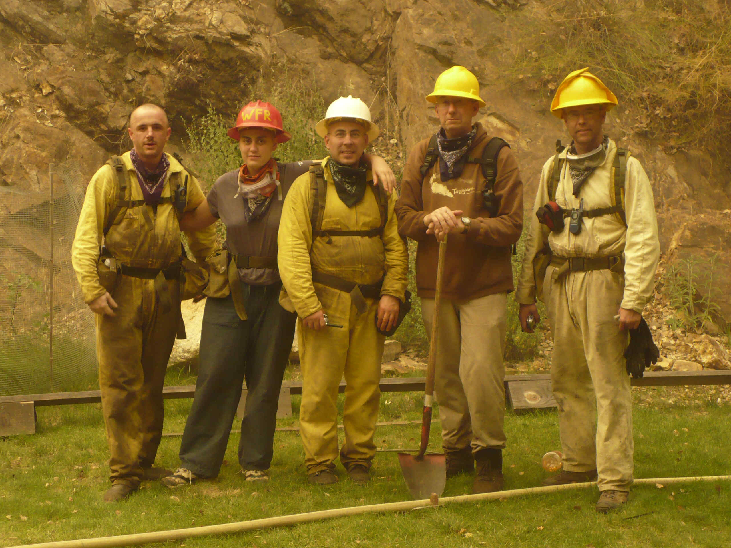
As to fire, the Basin Complex Fire is still grinding its way towards Carmel Valley. It blew through Tassajara on Thursday afternoon last week, where five monks, alone against 30 foot flames, managed to save Tassajara Zen Mountain Center. The photo of the five fire monks is everywhere (cuke.com had it first, and it's still the only post-fire picture out there). Shundo's Last Set of Fire Photos shows the final preparations, the Forest Service's sudden decision to evacuate, and the retreat up the road (protected by water bombers) of the other 15 residents then in Tassajara. It does not show the moment that Graham Ross, Mako Voelkel, David Zimmerman, Steve Stücky and Colin Gipson decided to decline evacuation, turn back, establish themselves in the safe space prepared, and keep the pumps running...
Monday, July 14, 2008
Dragonfly Wings in the Harbor
Yesterday late drove out on Ediz Hook after a long day of doing little but reading fire news and looking out the windows at the blue water of the Strait. Hadn't seen windsurfers before: against the whitecapped water in the harbor, the transparent sails disappeared and all I saw were strange little vertical marks speeding back and forth. Both pilot boats were docked and no big ships in sight, so I parked on the inner side of the Hook where the wind people were staging their gear; watched them flit out and back, out and back, for a long time; sometimes they nailed their turn, sometimes splat.
One of the pilot boats went to meet Norwegian Pearl and Holland America Westerdam, outward bound and dropping off the pilots who had brought them from the cruise docks in Seattle. Pearl is easy to identify without help from binoculars or cruise schedules: those goofy colored pearls painted on her sides really stand out from a distance.


Pilot boat came back in without waiting for the third cruise ship to appear; the returning pilots went into the station. I read my book, sitting inside the car as it was quite spectacularly windy. Suddenly noticed the other pilot boat had taken off, looked around and there was Maersk Wave, inbound, slowing down to pick up its pilot. Turns out these big blocky boats are vehicle carriers. Pilot boat put a pilot on Maersk Wave, then headed out to pick up the pilot from Star Princess, the third cruise ship, just emerging from the mist on the water.

Sunday, July 13, 2008
Back Home Again
Eight days in Tucson, studying old age and suffering in the guise of mom's health adventure — and spending all online time reading fire news about Elsewhere connected to me by such a long ago Elsewhen that it brings back the old age question from another angle. But now...
Bright sun, cool breeze off the water. Back where to the north is another country seen across salt water,

to the south the late spring snows are melting fast on the margins of the Olympics,

and cruise ships cross the bottom of the street.

Tuesday, July 08, 2008
Fire News from the Elsewhere
Things are hot: Sitting With Fire blog, especially this morning's Wrapping Things Up post. (!!) Big Sur/Ventana Wilderness Fire News. SFZC's own daily map is very clear about where the action is in relation to Tassajara, but only posted once a day, not nearly often enough. Firefighter Blog has a post about the astonishing hour-by-hour sometimes moment-by-moment information coming out from the fire crews and from satellite detection and being laid onto Google Earth. This immediate technical magic being performed by people who can wield the Google Earth tool is simply a wonder.
Sunday, July 06, 2008
At the Foot of Hurricane Hill
July 3, an evening picnic.


Thursday, July 03, 2008
Elsewhere Entirely : The Fire at Tassajara
Far away in time: nearly thirty years ago I lived at Tassajara Zen Mountain Center for five practice periods, two and a half years. Far away in how it is right now: all this water in my life; there they are waiting for the Basin Complex Fire to arrive, or not. And not so much difference, either way, from the perspective of the forest and the brushy hills, which are going to burn this time or next, and indeed mostly burned in 1977, the Marble Cone Fire. From the perspective of people, places that will never be the same in our lifetime are burning. On the Big Sur coast, infrastructures and livelihoods are burning; a few miles behind them in the mountains, the monastery buildings will burn, most likely; or perhaps be left saved in a wasteland of ash; breaking a lot of hearts either way.

I never saw the Ventana Wilderness as it had been, it burned two years before I came; but hiked over the ridge my first or second summer and there was unburned forest in Willow Creek, huge trees. Burning now. "Several fire trucks, at least 15, sped by Jamesburg this afternoon from many different counties, including Contra Costa, LA and Ventura. Only two went all the way into Tassajara bringing in supplies such as hard hats and goggles and foam. The fires continue to creep towards Tassajara from the Willow Creek and Tasssajara Creek watersheds, and from the ‘Oryoki Bowls’ (the W, NW, and SW)."
Right now Firefighter Blog has the most recent image from GeoMac, and it's scary scary. The fire is doing what it pleases. The fire season has only just begun. Months more of this, in many other people's beloved places. Centuries more of it, as the earth warms. ZMC's page is posting a screen grab of the Forest Service's hourly CONUS data Google Earth file once a day. The Los Padres National Forest current conditions page missed yesterday's updates. They're busy. Tassajara's own page sometimes is most current, as in the quote above. The folks at Jamesburg are keeping a Sitting With Fire blog.
Wednesday, July 02, 2008
Shipwatching
A couple of days ago, out on the Hook. Pilot boat went out into the Strait and put a pilot on the inbound Overseas Los Angeles, a tug went out to join her, pilot boat returned to berth. I thought they were headed into Puget Sound, but Overseas LA and escort tug proceeded into the harbor, passed several other moored tankers, and parked with Klahane Ridge in the background. Pilot boat went out into the harbor and retrieved the pilot. I was never able to read the name of the tug.

Portrait of a Foss tug. Can't remember what scrap of paper I scribbled its name on. Blue structure in the background is a chip loader. Behind it, the bluff at the foot of my neighborhood. Skyline shows Unicorn Peak and Hurricane Hill.

Holiday week in both countries on the Strait, Canada Day yesterday, Independence Day on Friday. A flotilla of wooden sailing "tall ships" including a replica of the Bounty were here in harbor, en route to or from Victoria, sailing around islands, reappearing in the harbor a few days later. Not as tall as the behemoth tankers, not as doughty as Coho. Not an effort to bring back and carry forward, as are the northwest tribal canoes we will soon be seeing out on the water. It didn't seem worth rushing down to the dock to look at them.
Saturday, June 28, 2008
Where The Water Comes From
The City of Port Angeles says:
The Water Utility maintains the city drinking water system from a well on the Elwha River to the meter by your house... The water system has approximately 189 miles of pipe ranging from 2 to 30 inches in diameter, 3 water booster pump stations, 5 reservoirs with 18 million gallons of storage and about 7,928 service connections. The water is disinfected using sodium hypochlorite (household bleach) and no other chemicals are added. The water supply is obtained from a 60 foot deep Collector Well next to the Elwha River which is a few miles west of town. The well and pumping system is designed to provide 11 million gallons per day (mgd).
Newspaper article from the Peninsula Daily News helps clarify the question of the PA water supply and the construction projects which are prerequisite to the Elwha Dam removals. Aha: this very recent article amends the question of what chemicals they are using, and says the water treatment plant completion dates are 2009 and 2010. (The dams don't come out until the plants are operating, you understand...)
Friday, June 27, 2008
All Over the Map
M.C. is visiting. Thursday we went to Rialto Beach, and walked to Hole in the Wall in a light rain that gradually let up; on the way back we saw something neither of us had ever seen before: a deer on the beach. Then for geographic thoroughness we went around to the river mouth on the La Push side, and watched the bald eagles perching around on snags and drift logs, waiting for fish.


Across the hills and back along the Strait by 113 and 112. Lots of cow parsnip and foxglove on the roadsides. Also stupendous lots of Scotch broom, but that's highly invasive and pernicious, and it's bad form to appreciate it. We detoured to try to get a glimpse of Salt Creek Farm where our veggies come from; but fierce dogs chased us away.
From there bypassed home and straight out onto Ediz Hook where we shipwatched gleefully, watched the harbor as the pilot boat whisked out to Alaskan Frontier very nearby, watched the pilot go up the ladder, watched the anchor chain slowly pulled up, watched the tug push the ship 180 degrees around so it was heading in the right direction, and watched the tug and the ship start slowly towards the harbor mouth and the Sound, too busy with the binoculars to think of taking pictures...

Map begins in town because we had a post office errand before we could start, and ends out on the Hook, and shows us larking all around the West End in between.
Wednesday, June 25, 2008
Daylight
Woke up this morning about 4AM and the birds were chirping. I shuffled to the front window to try to get a compass bearing on Polaris, but there was already lots of light and color along the horizon, officially too early for civil twilight or no.
" Wednesday 25 June 2008 Pacific Daylight Time
SUN
Begin civil twilight 4:34 a.m.
Sunrise 5:15 a.m.
Sun transit 1:17 p.m.
Sunset 9:18 p.m.
End civil twilight 9:59 p.m."
I missed the actual solstice day and several following—variously due to sleepiness, clouds, breakdowns in the brain/compass interface, and loss of the scrap of paper on which I wrote the bearing the day before yesterday—but it doesn't change much right around the solstices. Earliest sunrise was several days earlier anyway—as often as I almost grasp it, the geometry gets away from me, but I know I am at 48.12N or so, and I know where the sun crossed the horizon this morning. Pointed the compass at it, decided that was irrelevant, memorized the spot.


Yes, Mount Baker is really there, over the house with the red siding on the right side of the picture. Look for a white ghostly pointy shape. You need industrial strength lenses to get a good picture of it from here.)
Not getting enough sleep. Impossible to think it's sleepingtime as long as the long blue dusks are filling the apartment, well after ten PM before I can bear to close the curtains.
Monday, June 23, 2008
Solstice + 2
Yesterday was glorious. Warm, bright. A couple of resident eagles launching from the trees and cruising around and then landing back. Even over the sound of the waves you could hear one when it called. I stopped for a long time on a drift log as perfectly shaped for sitting as one of J. B. Blunk's redwood benches, to listen to the whoosh of water displacing air as the waves reached higher up the beach and seeped in among the pebbles; and the sound of the rocks clattering against each other as the withdrawing waves rolled them down the shore, stopped, rolled them back up.
I decided early on that it was warm enough for shoes that can get wet, and warm enough that on the way back I needn't bother dodging too hard to escape the tide. I let the waves catch me if they would. Misjudged slightly. Wet to the waist and nearly got the camera wet. Oh it was glorious.
The only thing missing was pelicans; they're around, I saw some last time, but none yesterday.


Saturday, June 21, 2008
Dam Removal
When it happens here, it will be on a very different scale. Marmot was 50 feet high, and its lake contained 900,000 cubic yards of sediment. The dams on the Elwha , scheduled for removal in 2012 (location map) are much bigger. Elwha Dam is 108 feet high and walls up 5 million cubic yards of sediment; and Glines Canyon Dam is 210 feet high and walls up 13 million cubic yards of sediment.
When W.C. was here last week we went out to look at the two dams, and try to imagine the river's future. He took the pictures. (Lots of links about the Elwha.)


Wednesday, June 18, 2008
Point Wilson Light, Port Townsend


Reading News
There hasn't been a piece of fiction I'm actively interested in, or one I'd been on the waiting list for, since the beginning of the month. I wander around the public library hoping for inspiration. Nope. I check my online record about thirty times a day in case any of my requests have come in. Hope? Nope. So in the mystery realm I read things that aren't even what P.W. used to call "acceptable material"; some of them so awful I'll never admit I'm reading them.
Meanwhile there are several non-fiction books in hand. I had to return The Great Warming unread, as people were waiting for it and it couldn't be renewed; and I'd gotten stubborn about finishing John Leland's little Kerouac book. One person waiting for the whale song book, so I'm working on that one next.
Thursday, June 12, 2008


Saturday, June 07, 2008
Mrs. Anna's
Hummingbird yesterday, towards sunset. On the feeder by the front door, not the new one. A female, maybe an Anna's. The first in a couple of weeks. Birdweb says,
Migration Status. Anna's Hummingbird migration has been described as a succession of movements and temporary residences wherever suitable flowers and feeders are found. In Washington, Anna's Hummingbird appears throughout the year. It is unclear whether this is due to migration or whether the birds we see in January are the same as those we see in June.
Conservation Status. Historically limited to western California, in recent years Anna's Hummingbirds have dramatically expanded their range northward as far as British Columbia. This expansion has been attributed to hummingbird feeders and gardens with exotic flowers that provide the birds with a year-round food source. Climate change may also play a role. They are currently very common across much of their range, and because they adapt well to suburban areas, should continue to thrive in the future.
Thursday, June 05, 2008
Shipspotting
Need a better camera. It's filling up with dim distant thumbnail images of cruise ships queueing up to drop off their Puget Sound Pilots at the end of Ediz Hook on Sunday evening, having all left Seattle for one-week cruises four hours before; and freighters and tankers and ferries and mystery ships. What kind of ship, if you please, was CSAV Rio Grande, which looks rather like a black helicopter of the sea and was inbound past the Hook Sunday evening? Oooh look, it arrived in San Francisco yesterday from Tacoma. Didn't take it long; into Puget Sound, out of Puget Sound, chug chug chug.
Alaskan Frontier, who came in a week ago, is still in port here. For several days she's been at the dock— no doubt it has a correct name— between the K-Ply plant and where Silverstar and Gemstone were parked. It's hard to imagine what kind of work or repair is being done to Frontier which could take so long that still it makes sense to do here instead of in some larger port.
MV HOS Gemstone and Silverstar were making their way back along the shore, and came back into port while I was out there this evening. I looked them up just now and whoa nellie!! Are they really still leased by the Navy as submarine escorts? What are they doing spending any of their their days docked at the bottom of Cedar Street off Marine Drive? I'm prepared to swear they had a handful of containers on them just now...
The tanker Sonangol Namibe is the only ship presently anchored out in the middle of the harbor, by far the most exotic name I've scribbled down lately.
There were half a dozen small boat trailers parked by the boat ramp. I asked some guys going out what they were going to catch, they said ling cod and sea bass. I asked some guys coming in. They said halibut (but they hadn't caught any.) There were mystery ducks. Black all over except some white bits on the wings. Beaks were wrong for scoters. Mysteries.


Sunday, June 01, 2008
Small Tidal Range, Not Much Surf

Three weeks since last ocean visit; such a relief to be there, listening. Listening to a fairly quiet slosh of water coming and going. People walking. One eagle. One duck barely sighted (first glance seemed to be a grebe, but the beak looked like a merganser, disappeared before sorted out). Walked along in the swash, unwilling to run away from the waves, eventually getting wet well above my boot tops.
Sitting on a pebble dune, reading; dry to the knees, then damp to the hips; book in one hand, the other sifting the small cobbles, adding one ever-so-smooth seductive stone after another to my shirt pocket. Brain engaged, but fingers in love with fine-grained dark rock.